Leave Yoksun for Kinchinjunga — Ascend Ratong valley — Salt-smuggling over Ratong — Landslips — Plants — Buckeem — Blocks of gneiss — Mon Lepcha — View — Weather — View from Gubroo — Kinchinjunga, tops of — Pundim cliff — Nursing — Vegetation of Himalaya — Coup d’œil of Jongri — Route to Yalloong — Arduous route of salt-traders from Tibet — Kinchin, ascent of — Lichens — Surfaces sculptured by snow and ice — Weather at Jongri — Snow — Shades for eyes.
I left Yoksun on an expedition to Kinchinjunga on the 7th of January. It was evident that at this season I could not attain any height; but I was most anxious to reach the lower limit of that mass of perpetual snow which descends in one continuous sweep from 28,000 to 15,000 feet, and radiates from the summit of Kinchin, along every spur and shoulder for ten to fifteen miles, towards each point of the compass.
The route lay for the first mile over the Yoksun flat, and then wound along the almost precipitous east flank of the Ratong, 1000 feet above its bed, leading through thick forest. It was often difficult, crossing torrents by calms of bamboo, and leading up precipices by notched poles and roots of trees. I wondered what could have induced the frequenting of such a route to Nepal, when there were so many better ones over Singalelah, till I found from my guide that he had habitually smuggled salt over this pass to avoid the oppressive duty levelled by the Dewan on all imports from Tibet by the eastern passes: he further told
me that it took five days to reach Yalloong in Nepal front Yoksun, on the third of which the Kanglanamo pass is crossed, which is open from April to November, but is always heavily snowed. Owing to this duty, and the remoteness of the eastern passes, the people on the west side of the Great Rungeet were compelled to pay an enormous sum for salt; and the Lamas of Changachelling and Pemiongchi petitioned Dr. Campbell to use his influence with the Nepal Court to have the Kanglanamo pass re-opened, and the power of trading with the Tibetans of Wallanchoon, Yangma, and Kambachen, restored to them: the pass having been closed since the Nepalese war, to prevent the Sikkim people from kidnapping children and slaves, as was alleged to be their custom.*
We passed some immense landslips, which had swept the forest into the torrent, and exposed white banks of angular detritus of gneiss and granite: we crossed one 200 yards long, by a narrow treacherous path, on a slope of 35°: the subjacent gneiss was nearly vertical, striking north-east. We camped at 6,670 feet, amongst a vegetation I little expected to find so close to the snows of Kinchin; it consisted of oak, maple, birch, laurel, rhododendron, white Daphne, jessamine, Arum, Begonia, Cyrtandraceæ, pepper, fig, Menispermum, wild cinnamon, Scitamineæ, several epiphytic orchids, vines, and ferns in great abundance.
On the following day, I proceeded north-west up the Ratong river, here a furious torrent; which we crossed,
* An accusation in which there was probably some truth; for the Sikkim Dingpun, who guided Dr. Campbell and myself to Mainom, Tassiding, etc., since kidnapped, or caused to be abducted, a girl of Brahmin parents, from the Mai valley of Nepal, a transaction which cost him some 300 rupees. The Nepal Durbar was naturally furious, the more so as the Dingpun had no caste, and was therefore abhorred by all Brahmins. Restitution was demanded through Dr. Campbell, who caused the incensed Dingpun to give up his paramour and her jewels. He vowed vengeance against Dr. Campbell, and found means to gratify it, as I shall hereafter show.
and then ascended a very steep mountain called “Mon Lepcha.” Immense detached masses of gneiss, full of coarse garnets, lay on the slope, some of which were curiously marked with a series of deep holes, large enough to put one’s fist in, and said to be the footprints of the sacred cow. They appeared to me to have been caused by the roots of trees, which spread over the rocks in these humid regions, and wear channels in the hardest material, especially when they follow the direction of its lamination or stratification.
I encamped at a place called Buckeem (alt. 8,650 ft.), in a forest of Abies Brunoniana and Webbiana, yew, oak, various rhododendrons, and small bamboo. Snow lay in patches at 8000 feet, and the night was cold and clear. On the following morning I continued the ascent, alternately up steeps and along perfectly level shelves, on which were occasionally frozen pools, surrounded with dwarf juniper and rhododendrons. Across one I observed the track of a yak in the snow; it presented two ridges, probably from the long hair of this animal, which trails on the ground, sweeping the snow from the centre of its path. At 11,000 feet the snow lay deep and soft in the woods of silver fir, and the coolies waded through it with difficulty.
Enormous fractured boulders of gneiss were frequent over the whole of Mon Lepcha, from 7000 to 11,000 feet: they were of the same material as the rock in situ, and as unaccountable in their origin as the loose blocks on Dorjiling and Sinchul spurs at similar elevations, often cresting narrow ridges. I measured one angular detached block, forty feet high, resting on a steep narrow shoulder of the spur, in a position to which it was impossible it could have rolled; and it is equally difficult to suppose that glacial ice deposited it 4000 feet above the bottom of the gorge,
except we conclude the valley to have been filled with ice to that depth. A glance at the map will show that Mon Lepcha is remarkably situated, opposite the face of Kinchinjunga, and at the great bend of the Ratong. Had that valley ever been filled with water during a glacial period, Mon Lepcha would have formed a promontory, and many floating bergs from Kinchin would have been stranded on its flank: but I nowhere observed these rocks to be of so fine a granite as I believe the upper rocks of Kinchin to be, and I consequently cannot advance even that far-fetched solution with much plausibility.
As I ascended, the rocks became more granitic, with large crystals of mica. The summit was another broad bare flat, elevated 13,080 feet, and fringed by a copse of rose, berberry, and very alpine rhododendrons: the Himalayan heather (Adromeda fastigiata) grew abundantly here, affording us good fuel.
The toilsome ascent through the soft snow and brushwood delayed the coolies, who scarcely accomplished five miles in the day. Some of them having come up by dark, I prepared to camp on the mountain-top, strewing thick masses of Andromeda and moss (which latter hung in great tufts from the bushes) on the snow; my blankets bad not arrived, but there was no prospect of a snow-storm.
The sun was powerful when I reached the summit, and I was so warm that I walked about barefoot on the frozen snow without inconvenience, preferring it to continuing in wet stockings: the temperature at the time was 29·5°, with a brisk south-east moist wind, and the dew point 22·8°.
The night was magnificent, brilliant starlight, with a pale mist over the mountains: the thermometer fell to 15·5° at 7.30 p.m., and one laid upon wood with its bulb freely exposed, sank to 7·5°: the snow sparkled with broad
flakes of hoar-frost in the full moon, which was so bright, that I recorded my observations by its light. Owing to the extreme cold of radiation, I passed a very uncomfortable night. The minimum thermometer fell to 1° in shade.* The sky was clear; and every rock, leaf, twig, blade of grass, and the snow itself, were covered with broad rhomboidal plates of hoar-frost, nearly one-third of an inch across: while the metal scale of the thermometer instantaneously blistered my tongue. As the sun rose, the light reflected from these myriads of facets had a splendid effect.
Before sunrise the atmosphere was still, and all but cloudless. To the south-east were visible the plains of India, at least 140 miles distant; where, as usual, horizontal layers of leaden purple vapour obscured the horizon: behind these the sun rose majestically, instantly dispersing them, while a thin haze spread over all the intervening mountains, from its slanting beams reaching me through otherwise imperceptible vapours: these, as the sun mounted higher, again became invisible, though still giving that transparency to the atmosphere and brilliant definition of the distances, so characteristic of a damp, yet clear day.
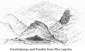
Mon Lepcha commands a most extensive view of Sikkim, southward to Dorjiling. At my feet lay the great and profound valley of the Ratong, a dark gulf of vegetation. Looking northward, the eye followed that river to the summit of Kinchinjunga (distant eighteen miles), which fronts the beholder as Mont Blanc does when seen from the mountains on the opposite side of the valley of Chamouni. To the east are the immense precipices and
* At sunrise the temperature was 11·5°; that of grass, cleared on the previous day from snow, and exposed to the sky, 6·5°; that on wool, 2·2°; and that on the surface of the snow, 0·7°.
glaciers of Pundim, and on the west those of Kubra, forming great supporters to the stupendous mountain between them. Mon Lepcha itself is a spur running south-east from the Kubra shoulder: it is very open, and covered with rounded hills for several miles further north, terminating in a conspicuous conical black hummock* called Gubroo, of 15,000 feet elevation, which presents a black cliff to the south.
Kinchinjunga rises in three heads, of nearly equal height,† which form a line running north-west. It exposes many white or grey rocks, bare of snow, and disposed in strata‡ sloping to the west; the colour of all which above 20,000 feet, and the rounded knobbed form of the summit, suggest a granitic formation. Lofty snowed ridges project from Kubra into the Ratong valley, presenting black precipices of stratified rocks to the southward. Pundim has a very grand appearance; being eight miles distant, and nearly 9000 feet above Mon Lepcha, it subtends an angle of 12°; while Kinchin top, though 15,000 feet higher than Mon Lepcha, being eighteen miles distant, rises only 9° 30 minutes above the true horizon: these angular heights are too small to give much grandeur and
* This I have beau told is the true Kubra; and the
great snowy mountain behind it, which I here, in conformity with
the Dorjiling nomenclature, call Kubra, has no name, being
considered a part of Kinchin.
† The eastern and western tops, are respectively 27,826 and
28,177 feet above the level of the sea.
‡ I am aware that the word strata is inappropriate here; the
appearance of stratification or bedding, if it indicate any
structure of the rock, being, I cannot doubt, due to that action
which gives parallel cleavage planes to granite in many parts of
the world, and to which the so-called lamination or foliation of
slate and gneiss is supposed by many geologists to be due. It is
not usual to find this structure so uniformly and conspicuously
developed through large masses of granite, as it appeared to me to
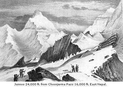
be on the sides of Kinchinjunga and on the top of Junnoo, as seen
from the Choonjerma pass (p.264,
plate); but it is sometimes very conspicuous, and nowhere more
than in the descent of the Grimsel towards Meyringen, where the
granite on the east flank of that magnificent gorge seems cleft
into parallel nearly vertical strata.
apparent elevation to mountains, however lofty; nor would they do so in this case, were it not that the Ratong valley which intervenes, is seen to be several thousand feet lower, and many degrees below the real horizon.
Pundim has a tremendous precipice to the south, which, to judge from its bareness of snow, must be nearly perpendicular; and it presented a superb geological section. The height of this precipice I found by angles with a pocket sextant to be upwards of 3,400 feet, and that of its top to be 21,300 above the sea, and consequently only 715 feet less than that of the summit of Pundim itself (which is 22,015 feet). This cliff is of black stratified rocks, sloping to the west, and probably striking north-west; permeated from top to bottom by veins of white granite, disposed in zigzag lines, which produce a contortion of the gneiss, and give it a marbled appearance. The same structure may be seen in miniature on the transported blocks which abound in the Sikkim rivers; where veins of finely grained granite are forced in
all directions through the gneiss, and form parallel seams or beds between the laminæ of that rock, united by transverse seams, and crumpling up the gneiss itself, like the crushed leaves of a book. The summit of Pundim itself is all of white rock, rounded in shape, and forming a cap to the gneiss, which weathers into precipices.
A succession of ridges, 14,000 to 18,000 feet high, presented a line of precipices running south from Pundim for several miles: immense granite veins are exposed on their surfaces, and they are capped by stratified rocks, sloping to the east, and apparently striking to the north-west, which, being black, contrast strongly with the white granite beneath them: these ridges, instead of being round-topped, are broken into splintered crags, behind which rises the beautiful conical peak of Nursing, 19,139 feet above the sea, eight miles distant, and subtending an angle of 8° 30′.
At the foot of these precipices was a very conspicuous series of lofty moraines, round whose bases the Ratong wound; these appeared of much the same height, rising several hundred feet above the valley: they were comparatively level-topped, and had steep shelving rounded sides.
I have been thus particular in describing the upper Ratong valley, because it drains the south face of the loftiest mountain on the globe; and I have introduced angular heights, and been precise in my details, because the vagueness with which all terms are usually applied to the apparent altitude and steepness of mountains and precipices, is apt to give false impressions. It is essential to attend to such points where scenery of real interest and importance is to be described. It is customary to speak of peaks as towering in the air, which yet subtend an angle of very few degrees; of almost precipitous ascents,
which, when measured, are found to be slopes of 18° or 20°; and of cliffs as steep and stupendous, which are inclined at a very moderate angle.
The effect of perspective is as often to deceive in details as to give truth to general impressions; and those accessories are sometimes wanting in nature, which, when supplied by art, give truth to the landscape. Thus, a streak of clouds adds height to a peak which should appear lofty, but which scarcely rises above the true horizon; and a belt of mist will sunder two snowy mountains which, though at very different distances, for want of a play of light and shade on their dazzling surfaces, and from the extreme transparency of the air in lofty regions, appear to be at the same distance from the observer.
The view to the southward from Mon Lepcha, including the country between the sea-like plains of India and the loftiest mountain on the globe, is very grand, and neither wanting in variety nor in beauty. From the deep valleys choked with tropical luxuriance to the scanty yak pasturage on the heights above, seems but a step at the first coup-d’oceil, but resolves itself on a closer inspection into five belts: 1, palm and plantain; 2, oak and laurel; 3, pine; 4, rhododendron and grass; and 5, rock and snow. From the bed of the Ratong, in which grow palms with screw-pine and plantain, it is only seven miles in a direct line to the perpetual ice. From the plains of India, or outer Himalaya, one may behold snowy peaks rise in the distance behind a foreground of tropical forest; here, on the contrary, all the intermediate phases of vegetation are seen at a glance. Except in the Himalaya this is no common phenomenon, and is owing to the very remarkable depth of the river-beds. That part of the valley of the Ratong where tropical vegetation ceases, is but 4000
feet above the sea, and though fully fifty miles as the crow flies (and perhaps 200 by the windings of the river) from the plains of India, is only eight in a straight line (and forty by the windings) from the snows which feed that river. In other words, the descent is so rapid, that in eight miles the Ratong waters every variety of vegetation, from the lichen of the poles to the palm of the tropics; whilst throughout the remainder of its mountain course, it falls from 4000 to 300 feet, flowing amongst tropical scenery, through a valley whose flanks rise from 5000 to 12,000 feet above its bed.
From Mon Lepcha we proceeded north-west towards Jongri, along a very open rounded bare mountain, covered with enormous boulders of gneiss, of which the subjacent rock is also composed. The soil is a thick clay full of angular stones, everywhere scooped out into little depressions which are the dry beds of pools, and are often strewed with a thin layer of pebbles. Black tufts of alpine aromatic rhododendrons of two kinds (R. anthopogon and setosum), with dwarf juniper, comprised all the conspicuous vegetation at this season.
After a two hours’ walk, keeping at 13,000 feet elevation, we sighted Jongri.* There were two stone huts on the bleak face of the spur, scarcely distinguishable at the distance of half a mile from the great blocks around
* I am assured by Capt. Sherwill, who, in 1852, proceeded along and surveyed the Nepal frontier beyond this point to Gubroo, that this is not Jongri, but Yangpoong. The difficulty of getting precise information, especially as to the names of seldom-visited spots, is very great. I was often deceived myself, undesignedly, I am sure, on the part of my informants; but in this case I have Dr. Campbell’s assurance, who has kindly investigated the subject, that there is no mistake on my part. Captain Sherwill has also kindly communicated to me a map of the head waters of the Rungbee, Yungya, and Yalloong rivers, of which, being more correct than my own, I have gladly availed myself for my map. Gubroo, he informs me, is 15,000 feet in altitude, and dips in a precipice 1000 feet high, facing Kubra, which prevented his exploring further north.
them. To the north Gubroo rose in dismal grandeur, backed by the dazzling snows of Kubra, which now seemed quite near, its lofty top (alt. 24,005 feet) being only eight miles distant. Much snow lay on the ground in patches, and there were few remains of herbaceous vegetation; those I recognised were chiefly of poppy, Potentilla, gentian, geranium, fritillary, Umbelliferæ, grass, and sedges.
On our arrival at the huts the weather was still fine, with a strong north-west wind, which meeting the warm moist current from the Ratong valley, caused much precipitation of vapour. As I hoped to be able to visit the surrounding glaciers from this spot, I made arrangements for a stay of some days: giving up the only habitable hut to my people, I spread my blankets in a slope from its roof to the ground, building a little stone dyke round the skirts of my dwelling, and a fire-place in front.
Hence to Yalloong in Nepal, by the Kanglanamo pass, is two days’ march: the route crosses the Singalelah range at an elevation of about 15,000 feet, south of Kubra, and north of a mountain that forms a conspicuous feature south-west from Jongri, as a crest of black fingered peaks, tipped with snow.
It is difficult to conceive the amount of labour expended upon every pound of salt imported into this part of Sikkim from Tibet, and as an enumeration of the chief features of the routes it must follow, will give some idea of what the circuit of the loftiest mountain in the globe involves, I shall briefly allude to them; premising that the circuit of Mont Blanc may be easily accomplished in four days. The shortest route to Yoksun (the first village south of Kinchin) from the nearest Tibetan village north of that mountain, involves a detour of one-third of the
circumference of Kinchin. It is evident that the most direct way must be that nearest the mountain-top, and therefore that which reaches the highest accessible elevation on its shoulders, and which, at the same time, dips into the shallowest valleys between those shoulders. The actual distance in a straight line is about fifty miles, from Yoksun to the mart at or near Tashirukpa.
The marches between them are as follows:—
1. To Yalloong two days; crossing Kanglanamo pass, 15,000 feet
high.
3. To foot of Choonjerma pass, descending to 10,000 feet.
4. Cross Choonjerma pass, 15,260 feet, and proceed to Kambachen,
11,400 feet.
5. Cross Nango pass, 15,770, and camp on Yangma river, 11,000
feet.
6. Ascend to foot of Kanglachem pass, and camp at 15,000 feet.
7. Cross Kanglachem pass, probably 16,500 feet; and
8-10. It is said to be three marches hence to the Tibetan
custom-house, and that two more snowy passes are crossed.
This allows no day of rest, and gives only five miles—as the crow flies—to be accomplished each day, but I assume fully fourteen of road distance; the labour spent in which would accomplish fully thirty over good roads. Four snowed passes at least are crossed, all above 15,000 feet, and after the first day the path does not descend below 10,000 feet. By this route about one-third of the circuit of Kinchinjunga is accomplished. Supposing the circuit were to be completed by the shortest practicable route, that is, keeping as near the summit as possible, the average time required for a man with his load would be upwards of a month.
To reach Tashirukpa by the eastern route from Yoksun, being a journey of about twenty-five days, requires a long detour to the southward and eastward, and afterwards the ascent of the Teesta valley, to Kongra Lama, and so north to the Tibetan Arun.
My first operation after encamping and arranging my instruments, was to sink the ground thermometer; but the earth being frozen for sixteen inches, it took four men several hours’ work with hammer and chisel, to penetrate so deep. There was much vegetable matter for the first eight or ten inches, and below that a fine red clay. I spent the afternoon, which was fine, in botanising. When the sun shone, the smell of the two rhododendrons was oppressive, especially as a little exertion at this elevation brings on headache. There were few mosses; but crustaceous lichens were numerous, and nearly all of them of Scotch, Alpine, European, and Arctic kinds. The names of these, given by the classical Linnæus and Wahlenberg, tell in some cases of their birth-places, in others of their hardihood, their lurid colours and weather-beaten aspects; such as tristis, gelida, glacialis, arctica, alpina, saxatilis, polaris, frigida, and numerous others equally familiar to the Scotch botanist. I recognised many as natives of the wild mountains of Cape Horn, and the rocks of the stormy Antarctic ocean; since visiting which regions I had not gathered them. The lichen called geographicus was most abundant, and is found to indicate a certain degree of cold in every latitude; descending to the level of the sea in latitude 52° north, and 50° south, but in lower latitudes only to be seen on mountains. It flourishes at 10,000 feet on the Himalaya, ascending thence to 18,000 feet. Its name, however, was not intended to indicate its wide range, but the curious
maplike patterns which its yellow crust forms on the rocks.
Of the blocks of gneiss scattered over the Jongri spur, many are twenty feet in diameter. The ridge slopes gently south-west to the Choroong river, and more steeply north-east to the Ratong, facing Kinchin: it rises so very gradually to a peaked mountain between Jongri and Kubra, that it is not possible to account for the transport and deposit of these boulders by glaciers of the ordinary form, viz., by a stream of ice following the course of a valley; and we are forced to speculate upon the possibility of ice having capped the whole spur, and moved downwards, transporting blocks from the prominences on various parts of the spur.
The cutting up of the whole surface of this rounded mountain into little pools, now dry, of all sizes, from ten to about one hundred yards in circumference, is a very striking phenomenon. The streams flow in shallow transverse valleys, each passing through a succession of such pools, accompanying a step-like character of the general surface. The beds are stony, becoming more so where they enter the pools, upon several of the larger of which I observed curving ridges of large stones, radiating outwards on to their beds from either margin of the entering stream: more generally large stones were deposited opposite every embouchure.
This superficial sculpturing must have been a very recent operation; and the transport of the heavy stones opposite the entrance of the streams has been effected by ice, and perhaps by snow; just as the arctic ice strews the shores of the Polar ocean with rocks.
The weather had been threatening all day, northern and westerly currents contending aloft with the south-east
trade-wind of Sikkim, and meeting in strife over the great upper valley of the Ratong. Stately masses of white cumuli wheeled round that gulf of glaciers, partially dissipating in an occasional snow-storm, but on the whole gradually accumulating.
On my arrival the thermometer was 32°, with a powerful sun shining, and it fell to 28° at 4 p.m., when the north wind set in. At sunset the moon rose through angry masses of woolly cirrus; its broad full orb threw a flood of yellow light over the serried tops south of Pundim; thence advancing obliquely towards Nursing, “it stood tip-toe” for a few minutes on that beautiful pyramid of snow, whence it seemed to take flight and mount majestically into mid-air, illuminating Kinchin, Pundim, and Kubra.
I sat at the entrance of my gipsy-like hut, anxiously watching the weather, and absorbed in admiration of the moonrise, from which my thoughts were soon diverted by its fading light as it entered a dense mass of mare’s-tail cirrus. It was very cold, and the stillness was oppressive. I had been urged not to attempt such an ascent in January, my provisions were scanty, firewood only to be obtained from some distance, the open undulating surface of Jongri was particularly exposed to heavy snow-drifts, and the path was, at the best, a scarcely perceptible track. I followed every change of the wind, every fluctuation of the barometer and thermometer, each accession of humidity, and the courses of the clouds aloft. At 7 p.m., the wind suddenly shifted to the west, and the thermometer instantly rose from 20° to 30°. After 8 p.m., the temperature fell again, and the wind drew round from west by south to north-east, when the fog cleared off. The barometer rose no more than it usually does towards 10 p.m., and though it clouded again, with the temperature at 17°, the wind
seemed steady, and I went to bed with a relieved mind.
Jan. 10.—During the night the temperature fell to 11·2°, and at 6 a.m. was 19·8°, falling again to 17° soon after. Though clouds were rapidly coming up from the west and south-west, the wind remained northerly till 8 a.m., when it shifted to south-west, and the temperature rose to 25°. As it continued fine, with the barometer high, I ventured on a walk towards Gubroo, carefully taking bearings of my position. I found a good many plants in a rocky valley close to that mountain, which I in vain attempted to ascend. The air was 30°, with a strong and damp south-west wind, and the cold was so piercing, that two lads who were with me, although walking fast, became benumbed, and could not return without assistance. At 11 a.m., a thick fog obliged us to retrace our steps: it was followed by snow in soft round pellets like sago, that swept across the hard ground. During the afternoon it snowed unceasingly, the wind repeatedly veering round the compass, always from west to east by south, and so by north to west again. The flakes were large, soft, and moist with the south wind, and small, hard, and dry with the north. Glimpses of blue sky were constantly seen to the south, under the gloomy canopy above, but they augured no change. As darkness came on, the temperature fell to 15°, and it snowed very hard; at 6 p.m., it was 11°, but rose afterwards to 18°.
The night was very cold and wintry: I sat for some hours behind a blanket screen (which had to be shifted every few minutes) at my tent-door, keeping up a sulky fire, and peering through the snow for signs of improvement, but in vain. The clouds were not dense, for the moon’s light was distinct, shining on the glittering snow-flakes
that fell relentlessly: my anxiety was great, and I could not help censuring myself severely for exposing a party to so great danger at such a season. I found comfort in the belief that no idle curiosity had prompted me, and that with a good motive and a strong prestige of success, one can surmount a host of difficulties. Still the snow fell; and my heart sank, as my fire declined, and the flakes sputtered on the blackening embers; my little puppy, who had gambolled all day amongst the drifting white pellets, now whined, and crouched under my thick woollen cloak; the inconstant searching wind drifted the snow into the tent, whose roof so bagged in with the accumulation that I had to support it with sticks, and dreaded being smothered, if the weight should cause it to sink upon my bed during my sleep. The increasing cold drove me, however, to my blankets, and taking the precaution of stretching a tripod stand over my head, so as to leave a breathing hole, by supporting the roof if it fell in, I slept soundly, with my dog at my feet.
At sunrise the following morning the sky was clear, with a light north wind; about two feet of snow had fallen, the drifts were deep, and all trace of the path obliterated. The minimum thermometer had fallen to 3·7°, the temperature rose to 27° at 9 a.m., after which the wind fell, and with it the thermometer to 18°. Soon, however, southerly breezes set in, bringing up heavy masses of clouds.
My light-hearted companions cheerfully prepared to leave the ground; they took their appointed loads without a murmur, and sought protection for their eyes from the glare of the newly fallen snow, some with as much of my crape veil as I could spare, others with shades of brown paper, or of hair from the yaks’ tails, whilst a few had spectacle-shades of woven hair; and the Lepchas loosened their
pigtails, and combed their long hair over their eyes and faces. It is from fresh-fallen snow alone that much inconvenience is felt; owing, I suppose, to the light reflected from the myriads of facets which the crystals of snow present. I have never suffered inconvenience in crossing beds of old snow, or glaciers with weathered surfaces, which absorb a great deal of light, and reflect comparatively little, and that little coloured green or blue.
The descent was very laborious, especially through the several miles of bush and rock which lie below the summit: so that, although we started at 10 a.m., it was dark by the time we reached Buckeem, where we found two lame coolies, whom we had left on our way up, and who were keeping up a glorious fire for our reception.