Difficulty in procuring leave to enter Sikkim — Obtain permission to travel in East Nepal — Arrangements — Coolies — Stores — Servants — Personal equipment — Mode of travelling — Leave Dorjiling — Goong ridge — Behaviour of Bhotan coolies — Nepal frontier — Myong valley — Ilam — Sikkim massacre — Cultivation — Nettles — Camp at Nanki on Tonglo — Bhotan coolies run away — View of Chumulari — Nepal peaks to west — Sakkiazung — Buceros — Road to Wallanchoon — Oaks — Scarcity of water — Singular view of mountain-valleys — Encampment — My tent and its furniture — Evening occupations — Dunkotah — Crossridge of Sakkiazung — Yews — Silver-firs — View of Tambur valley — Pemmi river — Pebbly terraces — Geology — Holy springs — Enormous trees — Luculia gratissima — Khawa river, rocks of — Arrive at Tambur — Shingle and gravel terraces — Natives, indolence of — Canoe ferry — Votive offerings — Bad road — Temperature, etc. — Chingtam village, view from — Mywa river and Guola — House — Boulders — Chain-bridge — Meepo, arrival of — Fevers.
Owing to the unsatisfactory nature of our relations with the Sikkim authorities, to which I have elsewhere alluded, my endeavours to procure leave to penetrate further beyond the Dorjiling territory than Tonglo, were attended with some trouble and delay.
In the autumn of 1848, the Governor-General communicated with the Rajah, desiring him to grant me honourable and safe escort through his dominions; but this was at once met by a decided refusal, apparently admitting of no compromise. Pending further negotiations, which Dr. Campbell felt sure would terminate satisfactorily, though perhaps too late for my purpose, he applied to the Nepal Rajah for permission for me to visit the Tibetan passes, west of Kinchinjunga; proposing in the meanwhile to
arrange for my return through Sikkim. Through the kindness of Col. Thoresby, the Resident at that Court, and the influence of Jung Bahadoor, this request was promptly acceded to, and a guard of six Nepalese soldiers and two officers was sent to Dorjiling to conduct me to any part of the eastern districts of Nepal which I might select. I decided upon following up the Tambur, a branch of the Arun river, and exploring the two easternmost of the Nepalese passes into Tibet (Wallanchoon and Kanglachem), which would bring me as near to the central mass and loftiest part of the eastern flank of Kinchinjunga as possible.
For this expedition (which occupied three months), all the arrangements were undertaken for me by Dr. Campbell, who aforded me every facility which in his government position he could command, besides personally superintending the equipment and provisioning of my party. Taking horses or loaded animals of any kind was not expedient: the whole journey was to be performed on foot, and everything carried on men’s backs. As we were to march through wholly unexplored countries, where food was only procurable at uncertain intervals, it was necessary to engage a large body of porters, some of whom should carry bags of rice for the coolies and themselves too. The difficulty of selecting these carriers, of whom thirty were required, was very great. The Lepchas, the best and most tractable, and over whom Dr. Campbell had the most direct influence, disliked employment out of Sikkim, especially in so warlike a country as Nepal: and they were besides thought unfit for the snowy regions. The Nepalese, of whom there were many residing as British subjects in Dorjiling, were mostly run-aways from their own country, and afraid of being claimed, should they return to it, by the lords of the soil. To employ Limboos, Moormis,
Hindoos, or other natives of low elevations, was out of the question; and no course appeared advisable but to engage some of the Bhotan run-aways domiciled in Dorjiling, who are accustomed to travel at all elevations, and fear nothing but a return to the country which they have abandoned as slaves, or as culprits: they are immensely powerful, and though intractable to the last degree, are generally glad to work and behave well for money. The choice, as will hereafter be seen, was unfortunate, though at the time unanimously approved.
My party mustered fifty-six persons. These consisted of myself, and one personal servant, a Portuguese half-caste, who undertook all offices, and spared me the usual train of Hindoo and Mahometan servants. My tent and equipments (for which I was greatly indebted to Mr. Hodgson), instruments, bed, box of clothes, books and papers, required a man for each. Seven more carried my papers for drying plants, and other scientific stores. The Nepalese guard had two coolies of their own. My interpreter, the coolie Sirdar (or headman), and my chief plant collector (a Lepcha), had a man each. Mr. Hodgson’s bird and animal shooter, collector, and stuffer, with their ammunition and indispensables, had four more; there were besides, three Lepcha lads to climb trees and change the plant-papers, who had long been in my service in that capacity; and the party was completed by fourteen Bhotan coolies laden with food, consisting chiefly of rice with ghee, oil, capsicums, salt, and flour.
I carried myself a small barometer, a large knife and digger for plants, note-book, telescope, compass, and other instruments; whilst two or three Lepcha lads who accompanied me as satellites, carried a botanising box, thermometers, sextant and artificial horizon, measuring-tape,
azimuth compass and stand, geological hammer, bottles and boxes for insects, sketch-book, etc., arranged in compartments of strong canvass bags. The Nepal officer (of the rank of serjeant, I believe) always kept near me with one of his men, rendering innumerable little services. Other sepoys were distributed amongst the remainder of the party; one went ahead to prepare camping-ground, and one brought up the rear.
The course generally pursued by Himalayan travellers is to march early in the morning, and arrive at the camping-ground before or by noon, breakfasting before starting, or en route. I never followed this plan, because it sacrificed the mornings, which were otherwise profitably spent in collecting about camp; whereas, if I set off early, I was generally too tired with the day’s march to employ in any active pursuit the rest of the daylight, which in November only lasted till 6 p.m. The men breakfasted early in the morning, I somewhat later, and all had started by 10 a.m., arriving between 4 and 6 p.m. at the next camping-ground. My tent was formed of blankets, spread over cross pieces of wood and a ridge-pole, enclosing an area of 6 to 8 feet by 4 to 6 feet. The bedstead, table, and chair were always made by my Lepchas, as described in the Tonglo excursion. The evenings I employed in writing up notes and journals, plotting maps, and ticketing the plants collected during the day’s march.
I left Dorjiling at noon, on the 27th October, accompanied by Dr. Campbell, who saw me fairly off, the coolies having preceded me. Our direct route would have been over Tonglo, but the threats of the Sikkim authorities rendered it advisable to make for Nepal at once; we therefore kept west along the Goong ridge, a western prolongation of Sinchul.
On overtaking the coolies, I proceeded for six or seven miles along a zig-zag road, at about 7,500 feet elevation, through dense forests, and halted at a little hut within sight of Dorjiling. Rain and mist came on at nightfall, and though several parties of my servants arrived, none of the Bhotan coolies made their appearance, and I spent the night without food or bed, the weather being much too foggy and dark to send back to meet the missing men. They joined me late on the following day, complaining unreasonably of their loads, and without their Sirdar, who, after starting his crew, had returned to take leave of his wife and family. On the following day he appeared, and after due admonishment we started, but four miles further on were again obliged to halt for the Bhotan coolies, who were equally deaf to threats and entreaties. As they did not come up till dusk, we were obliged to encamp here, (alt. 7,400 feet) at the common source of the Balasun, which flows to the plains, and the Little Rungeet, whose course is north.
The contrast between the conduct of the Bhotan men and that of the Lepchas and Nepalese was so marked, that I seriously debated in my own mind the propriety of sending the former back to Dorjiling, but yielded to the remonstrances of their Sirdar and the Nepal guard, who represented the great difficulty we should have in replacing them, and above all, the loss of time, at this season a matter of great importance. We accordingly started again the following morning, and still keeping in a western direction, crossed the posts in the forest dividing Sikkim from Nepal, and descended into the Myong valley of the latter country, through which flows the river of that name, a tributary of the Tambur. The Myong valley is remarkably fine: it runs south-west from Tonglo, and its open
character and general fertility contrast strongly with the bareness of the lower mountain spurs which flank it, and with the dense, gloomy, steep, and forest-clad gorges of Sikkim. At its lower end, about twenty miles from the frontier, is the military fort of Ilam, a celebrated stockaded post and cantonment of the Ghorkas: its position is marked by a conspicuous conical hill. The inhabitants are chiefly Brahmins, but there are also some Moormis, and a few Lepchas who escaped from Sikkim during the general massacre in 1825. Among these is a man who had formerly much influence in Sikkim; he still retains his title of Kazee,* and has had large lands assigned to him by the Nepalese Government: he sent the usual present of a kid, fowls, and eggs, and begged me to express to Dr. Campbell his desire to return to his native country, and settle at Dorjiling.
The scenery of this valley is the most beautiful I know of in the lower Himalaya, and the Cheer Pine (P. longifolia) is abundant, cresting the hills; which are loosely clothed with clumps of oaks and other trees, bamboos, and bracken (Pteris). The slopes are covered with red clay, and separate little ravines luxuriantly clothed with tropical vegetation, amongst which flow pebbly streams of transparent cool water. The villages, which are merely scattered collections of huts, are surrounded with fields of rice, buckwheat, and Indian corn, which latter the natives were now storing in little granaries, mounted on four posts, men, women, and children being all equally busy. The quantity of gigantic nettles (Urtica heterophylla) on the skirts of these maize fields is quite wonderful: their long white stings look most formidable, but though they sting
* This Mahometan title, by which the officers of state are known in Sikkim, is there generally pronounced Kajee.
virulently, the pain only lasts half an hour or so. These, however, with leeches, mosquitos, peepsas, and ticks, sometimes keep the traveller in a constant state of irritation.
However civilised the Hindoo may be in comparison with the Lepcha, he presents a far less attractive picture to the casual observer; he comes to your camping-ground, sits down, and stares with all his might, but offers no assistance; if he bring a present at all, he expects a return on the spot, and goes on begging till satisfied. I was amused by the cool way in which my Ghorka guard treated the village lads, when they wanted help in my service, taking them by the shoulder, pulling out their knives for them, placing them in their bands, and setting them to cut down a tree, or to chop firewood, which they seldom refused to do, when a little such douce violence was applied.
My object being to reach the Tambur, north of the great east and west mountain ridge of Sakkiazung, without crossing the innumerable feeders of the Myong and their dividing spurs, we ascended the north flank of the valley to a long spur from Tonglo, intending to follow winding ridges of that mountain to the sources of the Pemmi at the Phulloot mountains, and thence descend.
On the 3rd November I encamped on the flank of Tonglo (called Nanki in Nepal), at 9,300 feet, about 700 feet below the western summit, which is rocky, and connected by a long flat ridge with that which I had visited in the previous May. The Bhotan coolies behaved worse than ever; their conduct being in all respects typical of the turbulent, mulish race to which they belong. They had been plundering my provisions as they went along, and neither their Sirdar nor the Ghorka soldiers
had the smallest authority over them. I had hired some Ghorka coolies to assist and eventually to replace them, and had made up my mind to send back the worst from the more populous banks of the Tambur, when I was relieved by their making off of their own accord. The dilemma was however awkward, as it was impossible to procure men on the top of a mountain 10,000 feet high, or to proceed towards Phulloot. No course remained but to send to Dorjiling for others, or to return to the Myong valley, and take a more circuitous route over the west end of Sakkiazung, which led through villages from which I could procure coolies day by day. I preferred the latter plan, and sent one of the soldiers to the nearest village for assistance to bring the loads down, halting a day for that purpose.
From the summit of Tonglo I enjoyed the view I had so long desired of the Snowy Himalaya, from north-east to north-west; Sikkim being on the right, Nepal on the left, and the plains of India to the southward; and I procured a set of compass bearings, of the greatest use in mapping the country. In the early morning the transparency of the atmosphere renders this view one of astonishing grandeur. Kinchinjunga bore nearly due north, a dazzling mass of snowy peaks, intersected by blue glaciers, which gleamed in the slanting rays of the rising sun, like aquamarines set in frosted silver. From this the sweep of snowed mountains to the eastward was almost continuous as far as Chola (bearing east-north-east), following a curve of 150 miles, and enclosing the whole of the northern part of Sikkim, which appeared a billowy mass of forest-clad mountains. On the north-east horizon rose the Donkia mountain (23,176 feet), and Chumulari (23,929). Though both were much more distant than the snowy ranges,
being respectively eighty and ninety miles off, they raised their gigantic heads above, seeming what they really were, by far the loftiest peaks next to Kinchinjunga; and the perspective of snow is so deceptive, that though 40 to 60 miles beyond, they appeared as though almost in the same line with the ridges they overtopped. Of these mountains, Chumulari presents many attractions to the geographer, from its long disputed position, its sacred character, and the interest attached to it since Turner’s mission to Tibet in 1783. It was seen and recognised by Dr. Campbell, and measured by Colonel Waugh, from Sinchul, and also from Tonglo, and was a conspicuous object in my subsequent journey to Tibet. Beyond Junnoo, one of the western peaks of Kinchinjunga, there was no continuous snowy chain; the Himalaya seemed suddenly to decline into black and rugged peaks, till in the far north-west it rose again in a white mountain mass of stupendous elevation at 80 miles distance, called, by my Nepal people, “Tsungau.”* From the bearings I took of it from several positions, it is in about lat. 27° 49′ and long. 86° 24′, and is probably on the west flank of the Arun valley and river, which latter, in its course from Tibet to the plains of India, receives the waters from the west flank of Kinchinjunga, and from the east flank of the mountain in question. It is perhaps one which has been seen and measured from the Tirhoot district by some of Colonel Waugh’s party, and which has been reported to be upwards of 28,000 feet in elevation; and it is the only mountain of the first class in magnitude between Gosainthan (north-east of Katmandoo) and Kinchinjunga.
* This is probably the easternmost and loftiest peak seen from Katmandoo, distant 78 miles, and estimated elevation 20,117 feet by Col. Crawford’s observations. See “Hamilton’s Nepal,” p. 346, and plate 1.
To the west, the black ridge of Sakkiazung, bristling with pines, (Abies Webbiana) cut off the view of Nepal; but south-west, the Myong valley could be traced to its junction with the Tambur about thirty miles off: beyond which to the south-west and south, low hills belonging to the outer ranges of Nepal rose on the distant horizon, seventy or eighty miles off; and of these the most conspicuous were the Mahavarati which skirt the Nepal Terai. South and south-east, Sinchul and the Goong range of Sikkim intercepted the view of the plains of India, of which I had a distant peep to the south-west only.
The west top of Tonglo is very open and grassy, with occasional masses of gneiss of enormous size, but probably not in situ. The whole of this flank, and for 1000 feet down the spur to the south-west, had been cleared by fire for pasturage, and flocks of black-faced sheep were grazing. During my stay on the mountain, except in the early morning, the weather was bleak, gloomy, and very cold, with a high south-west wind. The mean temperature was 41°, extremes 53·2/26°: the nights were very clear, with sharp hoar-frost; the radiating thermometer sank to 21°, the temperature at 3·5 feet depth was 51·5°.
A few of the Bhotan coolies having voluntarily returned, I left Tonglo on the 5th, and descended its west flank to the Mai, a feeder of the Myong. The descent was as abrupt as that on the east face, but through less dense forest; the Sikkim side (that facing the east) being much the dampest. I encamped at dark by a small village, (Jummanoo) at 4,360 feet, having descended 5000 feet in five hours. Hence we marched eastward to the village of Sakkiazung, which we reached on the third day, crossing en route several spurs 4000 to 6000 feet high, from the same ridge, and as many rivers, which all fall
into the Myong, and whose beds are elevated from 2,500 to 3000 feet.
Though rich and fertile, the country is scantily populated, and coolies were procured with difficulty: I therefore sent back to Dorjiling all but absolute indispensables, and on the 9th of November started up the ridge in a northerly direction, taking the road from Ilam to Wallanchoon. The ascent was gradual, through a fine forest, full of horn-bills (Buceros), a bird resembling the Toucan (“Dhunass” Lepcha); at 7000 feet an oak (Quercus semecarpifolia), “Khasrou” of the Nepalese, commences, a tree which is common as far west as Kashmir, but which I never found in Sikkim, though it appears again in Bhotan.* No oak in Sikkim attains a greater elevation than 10,000.] It forms a broad-headed tree, and has a very handsome appearance; its favourite locality is on grassy open shoulders of the mountains. It was accompanied by an Astragalus, Geranium, and several other plants of the drier interior parts of Sikkim. Water is very scarce along the ridge; we walked fully eight miles without finding any, and were at length obliged to encamp at 8,350 feet by the only spring that we should be able to reach. With respect to drought, this ridge differs materially from Sikkim, where water abounds at all elevations; and the cause is obviously its position to the westward of the great ridge of Singalelah (including Tonglo) by which the S.W. currents are drained of their moisture. Here again, the east flank was much the dampest and most luxuriantly wooded.
While my men encamped on a very narrow ridge, I ascended a rocky summit, composed of great blocks of gneiss, from which I obtained a superb view to the westward. Immediately below a fearfully sudden descent, ran
* This oak ascends in the N.W. Himalaya to the highest limit of forest (12,000 feet).
the Daomy River, bounded on the opposite side by another parallel ridge of Sakkiazung, enclosing, with that on which I stood, a gulf from 6000 to 7000 feet deep, of wooded ridges, which, as it were, radiated outwards as they ascended upwards in rocky spurs to the pine-clad peaks around. To the south-west, in the extreme distance, were the boundless plains of India, upwards of 100 miles off, with the Cosi meandering through them like a silver thread.
The firmament appeared of a pale steel blue, and a broad low arch spanned the horizon, bounded by a line of little fleecy clouds (moutons); below this the sky was of a golden yellow, while in successively deeper strata, many belts or ribbons of vapour appeared to press upon the plains, the lowest of which was of a dark leaden hue, the upper more purple, and vanishing into the pale yellow above. Though well defined, there was no abrupt division between the belts, and the lowest mingled imperceptibly with the hazy horizon. Gradually the golden lines grew dim, and the blues and purples gained depth of colour; till the sun set behind the dark-blue peaked mountains in a flood of crimson and purple, sending broad beams of grey shade and purple light up to the zenith, and all around. As evening advanced, a sudden chill succeeded, and mists rapidly formed immediately below me in little isolated clouds, which coalesced and spread out like a heaving and rolling sea, leaving nothing above their surface but the ridges and spurs of the adjacent mountains. These rose like capes, promontories, and islands, of the darkest leaden hue, bristling with pines, and advancing boldly into the snowy white ocean, or starting from its bed in the strongest relief. As darkness came on, and the stars arose, a light fog gathered round me, and I quitted with reluctance one of the most impressive and magic scenes I ever beheld.
Returning to my tent, I was interested in observing how well my followers had accommodated themselves to their narrow circumstances. Their fires gleamed everywhere amongst the trees, and the people, broken up into groups of five, presented an interesting picture of native, savage, and half-civilised life. I wandered amongst them in the darkness, and watched unseen their operations; some were cooking, with their rude bronzed faces lighted up by the ruddy glow, as they peered into the pot, stirring the boiling rice with one hand, while with the other they held back their long tangled hair. Others were bringing water from the spring below, some gathering sprigs of fragrant Artemisia and other shrubs to form couches—some lopping branches of larger trees to screen them from nocturnal radiation; their only protection from the dew being such branches stuck in the ground, and slanting over their procumbent forms. The Bhotanese were rude and boisterous in their pursuits, constantly complaining to the Sirdars, and wrangling over their meals. The Ghorkas were sprightly, combing their raven hair, telling interminably long stories, of which money was the burthen, or singing Hindoo songs through their noses in chorus; and being neater and better dressed, and having a servant to cook their food, they seemed quite the gentlemen of the party. Still the Lepcha was the most attractive, the least restrained, and the most natural in all his actions, the simplest in his wants and appliances, with a bamboo as his water-jug, an earthen-pot as his kettle, and all manner of herbs collected during the day’s march to flavour his food.
My tent was made of a blanket thrown over the limb of a tree; to this others were attached, and the whole was supported on a frame like a house. One half was occupied by my bedstead, beneath which was stowed my box of
clothes, while my books and writing materials were placed under the table. The barometer hung in the most out-of-the-way corner, and my other instruments all around. A small candle was burning in a glass shade, to keep the draught and insects from the light, and I had the comfort of seeing the knife, fork, and spoon laid on a white napkin, as I entered my snug little house, and flung myself on the elastic couch to ruminate on the proceedings of the day, and speculate on those of the morrow, while waiting for my meal, which usually consisted of stewed meat and rice, with biscuits and tea. My thermometers (wet and dry bulb, and minimum) hung under a temporary canopy made of thickly plaited bamboo and leaves close to the tent, and the cooking was performed by my servant under a tree.
After dinner my occupations were to ticket and put away the plants collected during the day, write up journals, plot maps, and take observations till 10 p.m. As soon as I was in bed, one of the Nepal soldiers was accustomed to enter, spread his blanket on the ground, and sleep there as my guard. In the morning the collectors were set to change the plant-papers, while I explored the neighbourhood, and having taken observations and breakfasted, we were ready to start at 10 a.m.
Following the same ridge, after a few miles of ascent over much broken gneiss rock, the Ghorkas led me aside to the top of a knoll, 9,300 feet high, covered with stunted bushes, and commanding a splendid view to the west, of the broad, low, well cultivated valley of the Tambur, and the extensive town of Dunkotah on its banks, about twenty-five miles off; the capital of this part of Nepal, and famous for its manufactory of paper from the bark of the Daphne. Hence too I gained a fine view of the plains of India, including the course of the Cosi river, which, receiving the
Arun and Tambur, debouches into the Ganges opposite Colgongl (see p.95).
A little further on we crossed the main ridge of Sakkiazung, a long flexuous chain stretching for miles to the westward from Phulloot on Singalelah, and forming the most elevated and conspicuous transverse range in this part of Nepal: its streams flow south to the Myong, and north to feeders of the Tambur. Silver firs (Abies Webbiana) are found on all the summits; but to my regret none occurred in our path, which led just below their limit (10,000 feet), on the southern Himalayan ranges. There were, however, a few yews, exactly like the English. The view that opened on cresting this range was again magnificent, of Kinchinjunga, the western snows of Nepal, and the valley of the Tambur winding amongst wooded and cultivated hills to a long line of black-peaked, rugged mountains, sparingly snowed, which intervene between Kinchinjunga and the great Nepal mountain before mentioned. The extremely varied colouring on the infinite number of hill-slopes that everywhere intersected the Tambur valley was very pleasing. For fully forty miles to the northward there were no lofty forest-clad mountains, nor any apparently above 4000 to 5000 feet: villages and hamlets appeared everywhere, with crops of golden mustard and purple buckwheat in full flower; yellow rice and maize, green hemp, pulse, radishes, and barley, and brown millet. Here and there deep groves of oranges, the broad-leafed banana, and sugar-cane, skirted the bottoms of the valleys, through which the streams were occasionally seen, rushing in white foam over their rocky beds. It was a goodly sight to one who had for his only standard of comparison the view from Sinchul, of the gloomy forest-clad ranges of 6000 to 10,000 feet, that intervene between that mountain and the snowy girdle of Sikkim;
though I question whether a traveller from more favoured climes would see more in this, than a thinly inhabited country, with irregular patches of poor cultivation, a vast amount of ragged forest on low hills of rather uniform height and contour, relieved by a dismal back-ground of frowning black mountains, sprinkled with snow! Kinchinjunga was again the most prominent object to the north-east, with its sister peaks of Kubra (24,005 feet), and Junnoo (25,312 feet). All these presented bare cliff’s for several thousand feet below their summits, composed of white rock with a faint pink tint:—on the other hand the lofty Nepal mountain in the far west presented cliffs of black rocks. From the summit two routes to the Tambur presented themselves; one, the main road, led west and south along the ridge, and then turned north, descending to the river; the other was shorter, leading abruptly down to the Pemmi river, and thence along its banks, west to the Tambur. I chose the latter.
The descent was very abrupt on the first day, from 9,500 feet to 5000 feet, and on that following to the bed of the Pemmi, at 2000 feet; and the road was infamously bad, generally consisting of a narrow, winding, rocky path among tangled shrubs and large boulders, brambles, nettles, and thorny bushes, often in the bed of the torrent, or crossing spurs covered with forest, round whose bases it flowed. A little cultivation was occasionally met with on the narrow flat pebbly terraces which fringed the stream, usually of rice, and sometimes of the small-leaved variety of hemp (Cannabis), grown as a narcotic.
The rocks above 5000 feet were gneiss; below this, cliffs of very micaceous schist were met with, having a north-west strike, and being often vertical; the boulders again were always of gneiss. The streams seemed rather to occupy faults, than to have eroded courses for themselves;
their beds were invariably rocky or pebbly, and the waters white and muddy from the quantity of alumina. In one little rocky dell the water gushed through a hole in a soft stratum in the gneiss; a trifling circumstance which was not lost upon the crafty Brahmins, who had cut a series of regular holes for the water, ornamented the rocks with red paint, and a row of little iron tridents of Siva, and dedicated the whole to Mahadeo.
In some spots the vegetation was exceedingly fine, and several large trees occurred: I measured a Toon (Cedrela) thirty feet in girth at five feet above the ground. The skirts of the forest were adorned with numerous jungle flowers, rice crops, blue Acanthaceæ and Pavetta, wild cherry-trees covered with scarlet blossoms, and trees of the purple and lilac Bauhinia; while Thunbergia, Convolvulus, and other climbers, hung in graceful festoons from the boughs, and on the dry micaceous rocks the Luculia gratissima, one of our common hot-house ornaments, grew in profusion, its gorgeous heads of blossoms scenting the air.
At the junction of the Pemmi and Khawa rivers, there are high rocks of mica-slate, and broad river-terraces of stratified sand and pebbles, apparently alternating with deposits of shingle. On this hot, open expanse, elevated 2250 feet, appeared many trees and plants of the Terai and plains, as pomegranate, peepul, and sal; with extensive fields of cotton, indigo, and irrigated rice.
We followed the north bank of the Khawa, which runs westerly through a gorge, between high cliffs of chlorite, containing thick beds of stratified quartz. At the angles of the river broad terraces are formed, fifteen to thirty feet above its bed, similar to those just mentioned, and planted with rows of Acacia Serissa, or laid out in rice fields, or sugar plantations.
I reached the east bank of the Tambur, on the 13th of November, at its junction with the Khawa, in a deep gorge. It formed a grand stream, larger than the Teesta, of a pale, sea-green, muddy colour, and flowed rapidly with a strong ripple, but no foam; it rises six feet in the rains, but ice never descends nearly so low; its breadth was sixty to eighty yards, its temperature 55° to 58°. The breadth of the foaming Khawa was twelve to fifteen yards, and its temperature 56·5°. The surrounding vegetation was entirely tropical, consisting of scrubby sal trees, acacia, Grislea, Emblica, Hibiscus, etc.; the elevation being but 1,300 feet, though the spot was twenty-five miles in a straight line from the plains. I camped at the fork of the rivers, on a fine terrace fifty feet above the water, about seventy yards long, and one hundred broad, quite flat-topped, and composed of shingle, gravel, etc., with enormous boulders of gneiss, quartz, and hornstone, much water-worn; it was girt by another broken terrace, twelve feet or so above the water, and covered with long grass and bushes.
The main road from Ilam to Wallanchoon, which I quitted on Sakkiazung, descends steeply on the opposite bank of the river, which I crossed in a canoe formed of a hollow trunk (of Toon), thirty feet long. There is considerable traffic along this road; and I was visited by numbers of natives, all Hindoos, who coolly squatted before my tent-door, and stared with their large black, vacant, lustrous eyes: they appear singularly indolent, and great beggars.
The land seems highly favoured by nature, and the population, though so scattered, is in reality considerable, the varied elevation giving a large surface; but the natives care for no more than will satisfy their immediate wants. The river swarms with fish, but they are too lazy to catch them, and they have seldom anything better to give or sell
than sticks of sugar-cane, which when peeled form a refreshing morsel in these scorching marches. They have few and poor oranges, citrons, and lemons, very bad plantains, and but little else;—eggs, fowls, and milk are all scarce. Horned cattle are of course never killed by Hindoos, and it was but seldom that I could replenish my larder with a kid. Potatos are unknown, but my Sepoys often brought me large coarse radishes and legumes.
From the junction of the rivers the road led up the Tambur to Mywa Guola; about sixteen miles by the river, but fully thirty-five, as we wound, ascended, and descended, during three days’ marches. We were ferried across the stream in a canoe much ruder than that of the New Zealander. I watched my party crossing by boat-loads of fifteen each; the Bhotan men hung little scraps of rags on the bushes before embarking, the votive offerings of a Booddhist throughout central Asia;—the Lepcha, less civilised, scooped up a little water in the palm of his hand, and scattered it about, invoking the river god of his simple creed.
We always encamped upon gravelly terraces a few feet above the river, which flows in a deep gorge; its banks are very steep for 600 feet above the stream, though the mountains which flank it do not exceed 4000 to 5000 feet: this is a constant phenomenon in the Himalaya, and the roads, when low and within a few hundred feet of the river, are in consequence excessively steep and difficult; it would have been impossible to have taken ponies along that we followed, which was often not a foot broad, running along very steep cliffs, at a dizzy height above the river, and engineered with much trouble and ingenuity: often the bank was abandoned altogether, and we ascended several thousand feet to descend again. Owing to the steepness of these banks, and the reflected
heat, the valley, even at this season, was excessively hot and close during the day, even when the temperature was below 70°, and tempered by a brisk breeze which rushes upwards from sunrise to sunset. The sun at this season does not, in many places, reach the bottom of these valleys until 10 a.m., and is off again by 3 p.m.; and the radiation to a clear sky is so powerful that dew frequently forms in the shade, throughout the day, and it is common at 10 a.m. to find the thermometer sink from 70° in a sheltered spot, dried by the sun, to 40° in the shade close by, where the sun has not yet penetrated. Snow never falls.
The rocks throughout this part of the river-course are mica-schists (strike north-west, dip south-west 70°, but very variable in inclination and direction); they are dry and grassy, and the vegetation wholly tropical, as is the entomology, which consists chiefly of large butterflies, Mantis and Diptera. Snowy mountains are rarely seen, and the beauty of the scenery is confined to the wooded banks of the main stream, which flows at an average inclination of fifty feet to the mile. Otters are found in the stream, and my party shot two, but could not procure them.
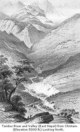
In one place the road ascended for 2000 feet above the river, to the village of Chingtam, situated on a lofty spur of the west bank, whence I obtained a grand view of the upper course of the river, flowing in a tremendous chasm, flanked by well-cultivated hills, and emerging fifteen miles to the northward, from black mountains of savage grandeur, whose rugged, precipitous faces were streaked with snow, and the tops of the lower ones crowned with the tabular-branched silver-fir, contrasting strongly with the tropical luxuriance around. Chingtam is an extensive village, covering an area of two miles, and surrounded with abundant
cultivation; the houses, which are built in clusters, are of wood, or wattle and mud, with grass thatch. The villagers, though an indolent, staring race, are quiet and respectable; the men are handsome, the women, though less so, often good-looking. They have fine cattle, and excellent crops.
Immediately above Chingtam, the Tambur is joined by a large affluent from the west, the Mywa, which is crossed by an excellent iron bridge, formed of loops hanging from two parallel chains, along which is laid a plank of sal timber. Passing through the village, we camped on a broad terrace, from sixty to seventy feet above the junction of the rivers, whose beds are 2100 feet above the sea.
Mywa Guola (or bazaar) is a large village and mart, frequented by Nepalese and Tibetans, who bring salt, wool, gold, musk, and blankets, to exchange for rice, coral, and other commodities; and a custom-house officer is stationed there, with a few soldiers. The houses are of wood, and well built: the public ones are large, with verandahs, and galleries of carved wood; the workmanship is of Chinese character, and inferior to that of Katmandoo; but in the same style, and quite unlike anything I had previously seen.
The river-terrace is in all respects similar to that at the junction of the Tambur and Khawa, but very extensive: the stones it contained were of all sizes, from a nut to huge boulders upwards of fifteen feet long, of which many strewed the surface, while others were in the bed of the river: all were of gneiss, quartz, and granite, and had doubtless been transported from great elevations, as the rocks in situ—both here and for several thousand feet higher up the river—were micaceous schists, dipping in various directions, and at all angles, with, however, a general strike to the north-west.
I was here overtaken by a messenger with letters from Dr. Campbell, announcing that the Sikkim Rajah had disavowed the refusal to the Governor-General’s letter, and authorising me to return through any part of Sikkim I thought proper. The bearer was a Lepcha attached to the court: his dress was that of a superior person, being a scarlet jacket over a white cotton dress, the breadth of the blue stripes of which generally denotes wealth; he was accompanied by a sort of attache, who wore a magnificent pearl and gold ear-ring, and carried his master’s bow, as well as a basket on his back; while an attendant coolie bore their utensils and food. Meepo, or Teshoo (in Tibetan, Mr.), Meepo, as he was usually called, soon attached himself to me, and proved an active, useful, and intelligent companion, guide, and often collector, during many months afterwards.
The vegetation round Mywa Guola is still thoroughly tropical: the banyan is planted, and thrives tolerably, the heat being great during the day. Like the whole of the Tambur valley below 4000 feet, and especially on these flats, the climate is very malarious before and after the rains; and I was repeatedly applied to by natives suffering under attacks of fever. During the two days I halted, the mean temperature was 60° (extremes, 80°/41°), that of the Tambur, 53°, and of the Mywa, 56°; each varying a few° (the smaller stream the most) between sunrise and 4 p.m.: the sunk thermometer was 72°.
As we should not easily be able to procure food further on, I laid in a full stock here, and distributed blankets, etc., sufficient for temporary use for all the people, dividing them into groups or messes.