Leave Lachoong for Tunkra pass — Moraines and their vegetation — Pines of great dimensions — Wild currants — Glaciers — Summit of pass — Elevation — Views — Plants — Winds — Choombi district — Lacheepia rock — Extreme cold — Kinchinjunga — Himalayan grouse — Meteorological observations — Return to Lachoong — Oaks — Ascent to Yeumtong — Flats and debacles — Buried pine-trunks — Perpetual snow — Hot springs — Behaviour of Singtam Soubah — Leave for Momay Samdong — Upper limit of trees — Distribution of plants — Glacial terraces, etc. — Forked Donkia — Moutonnéed rocks — Ascent to Donkia pass — Vegetation — Scenery — Lakes — Tibet — Bhomtso — Arun river — Kiang-lah mountains — Yaru-Tsampu river — Appearance of Tibet — Kambajong — Jigatzi — Kinchinjhow, and Kinchinjunga — Chola range — Deceptive appearance of distant landscape — Perpetual snow — Granite — Temperatures — Pulses — Plants — Tripe de roche — Return to Momay — Dogs and yaks — Birds — Insects — Quadrupeds — Hot springs — Marmots — Kinchinjhow glacier.
The Singtam Soubah being again laid up here from the consequences of leech-bites, I took the opportunity of visiting the Tunkra-lah pass, represented as the most snowy in Sikkim; which I found to be the case. The route lay over the moraines on the north flank of the Tunkrachoo, which are divided by narrow dry gullies,* and composed of enormous blocks disintegrating into a deep layer of clay. All are clothed with luxuriant herbage and flowering shrubs,† besides small larches and pines,
* These ridges of the moraine, separated by
gullies, indicate the progressive retirement of the ancient
glacier, after periods of rest. The same phenomena may be seen, on
a diminutive scale, in the Swiss Alps, by any one who carefully
examines the lateral and often the terminal moraines of any
retiring or diminishing glacier, at whose base or flanks are
concentric ridges, which are successive deposits.
† Ranunculus, Clematis, Thalictrum, Anemone, Aconitum
variegatum of Europe, a scandent species, Berberry, Deutzia,
Philadelphus, Rose, Honeysuckle, Thistles, Orchis,
Habenaria, Fritillaria, Aster, Calimeris, Verbascum thapsus,
Pedicularis, Euphrasia, Senecio, Eupatorium, Dipsacus,
Euphorbia, Balsam, Hypericum, Gentiana, Halenia, Codonopsis,
Polygonum.
rhododendrons and maples; with Enkianthus, Pyrus, cherry, Pieris, laurel, and Goughia. The musk-deer inhabits these woods, and at this season I have never seen it higher. Large monkeys are also found on the skirts of the pine-forests, and the Ailurus ochraceus (Hodgs.), a curious long-tailed animal peculiar to the Himalaya, something between a diminutive bear and a squirrel. In the dense and gigantic forest of Abies Brunoniana and silver fir, I measured one of the former trees, and found it twenty-eight feet in girth, and above 120 feet in height. The Abies Webbiana attains thirty-five feet in girth, with a trunk unbranched for forty feet.
The path was narrow and difficult in the wood, and especially along the bed of the stream, where grew ugly trees of larch, eighty feet high, and abundance of a new species of alpine strawberry with oblong fruit. At 11,560 feet elevation, I arrived at an immense rock of gneiss, buried in the forest. Here currant-bushes were plentiful, generally growing on the pine-trunks, in strange association with a small species of Begonia, a hothouse tribe of plants in England. Emerging from the forest, vast old moraines are crossed, in a shallow mountain valley, several miles long and broad, 12,000 feet above the sea, choked with rhododendron shrubs, and nearly encircled by snowy mountains. Magnificent gentians grew here, also Senecio, Corydalis, and the Aconitum luridum (n. sp.), whose root is said to be as virulent as A. ferox and A. Napellus.* The
* The result of Dr. Thomson’s and my examination of the Himplayan aconites (of which there are seven species) is that the one generally known as A. ferox, and which supplies a great deal of the celebrated poison, is the common A. Napellus of Europe.
plants were all fully a month behind those of the Lachen valley at the same elevation. Heavy rain fell in the afternoon, and we halted under some rocks: as I had brought no tent, my bed was placed beneath the shelter of one, near which the rest of the party burrowed. I supped off half a yak’s kidney, an enormous organ in this animal.
On the following morning we proceeded up the valley, towards a very steep rocky barrier, through which the river cut a narrow gorge, and beyond which rose lofty snowy mountains: the peak of Tunkra being to our left hand (north). Saxifrages grew here in profuse tufts of golden blossoms, and Chrysosplenium, rushes, mountain-sorrel (Oxyria), and the bladder-headed Saussurea, whose flowers are enclosed in inflated membranous bracts, and smell like putrid meat: there were also splendid primroses, the spikenard valerian, and golden Potentillas.
The ascent was steep and difficult, up a stony valley bounded by precipices; in this the river flowed in a north-west direction, and we were obliged to wade along it, though its waters were bitterly cold, the temperature being 39°. At 15,000 feet we passed from great snowbeds to the surface of a glacier, partly an accumulation of snow, increased by lateral glaciers: its slope was very gentle for several miles; the surface was eroded by rain, and very rough, whilst those of the lateral glaciers were ribboned, crevassed, and often conspicuously marked with dirt-bands.
A gently sloping saddle, bare of snow, which succeeds the glacier, forms the top of the Tunkra pass; it unites two snowy mountains, and opens on the great valley of the Machoo, which flows in a part of Tibet between Sikkim and Bhotan; its height is 16,083 feet above the sea by barometer, and 16,137 feet by boiling-point. Nothing can
be more different than the two slopes of this pass; that by which I had come presented a gentle snowy acclivity, bounded by precipitous mountains; while that which opened before me was a steep, rocky, broad, grassy valley, where not a particle of snow was to be seen, and yaks were feeding near a small lake not 1000 feet down. Nor were snowy mountains visible anywhere in this direction, except far to the south-east, in Bhotan. This remarkable difference of climate is due to the southerly wind which ascends the Tibetan or Machoo valley being drained by intervening mountains before reaching this pass, whilst the Sikkim current brings abundant vapours up the Teesta and Lachoong valleys.
Chumulari lies to the E.N.E. of the Tunkra pass, and is only twenty-six miles distant, but not seen; Phari is two marches off, in an easterly direction, and Choombi one to the south-east. Choombi is the general name given to a large Tibetan province that embraces the head of the Machoo river, and includes Phari, Eusa, Choombi, and about thirteen other villages, corresponding to as many districts, that contain from under a dozen to 300 houses each, varying with the season and state of trade. The latter is considerable, Phari being, next to Dorjiling, the greatest Tibetan, Bhotan, Sikkim, and Indian entrepôt along the whole Himalaya east of Nepal. The general form of Choombi valley is triangular, the broader end northwards: it is bounded by the Chola range on the west from Donkia to Gipmoochi, and by the Kamphee or Chakoong range to the east; which is, I believe, continuous with Chumulari. These meridional ranges approximate to the southward, so as to form a natural boundary to Choombi. The Machoo river, rising from Chumulari, flows through the Choombi district, and enters
Bhotan at a large mart called Rinchingoong, whence it flows to the plains of India, where it is called at Couch-Behar, the Torsha, or, as some say, the Godadda, and falls into the Burrampooter.
The Choombi district is elevated, for the only cultivation is a summer or alpine one, neither rice, maize, nor millet being grown there: it is also dry, for the great height of the Bhotan mountains and the form of the Machou valley cut off the rains, and there is no dense forest. It is very mountainous, all carriage being on men’s and yaks’ backs, and is populous for this part of the country, the inhabitants being estimated at 3000, in the trading season, when many families from Tibet and Bhotan erect booths at Phari.
A civil officer at Phari collects the revenue under the Lhassan authorities, and there is also a Tibetan fort, an officer, and guard. The inhabitants of this district more resemble the Bhotanese than Tibetans, and are a thievish set, finding a refuge under the Paro-Pilo of Bhotan,* who taxes the refugees according to the estimate he forms of their plunder. The Tibetans seldom pursue the culprits, as the Lhassan government avoids all interference south of their own frontier.
From Choombi to Lhassa is fifteen days’ long journeys for a man mounted on a stout mule; all the rice passing through Phari is monopolised there for the Chinese troops
* There was once a large monastery, called Kazioo Goompa, at Choombi, with upwards of one hundred Lamas. During a struggle between the Sikkim and Bhotan monks for superiority in it, the abbot died. His avatar reappeared in two places at once! in Bhotan as a relative of the Paro-Pilo himself, and in Sikkim as a brother of the powerful Gangtok Kajee. Their disputes were referred to the Dalai Lama, who pronounced for Sikkim. This was not to be disputed by the Pilo, who, however, plundered the Goompa of its silver, gold, and books, leaving nothing but the bare walls for the successful Lama! The Lhassan authorities made no attempt to obtain restitution, and the monastery has been consequently neglected.
at Lhassa. The grazing for yaks and small cattle is excellent in Choombi, and the Pinus excelsa is said to grow abundantly there, though unknown in Sikkim, but I have not heard of any other peculiarity in its productions.
Very few plants grew amongst the stones at the top of the Tunkra pass, and those few were mostly quite different from those of Palung and Kongra Lama. A pink-flowered Arenaria, two kinds of Corydalis, the cottony Saussurea, and diminutive primroses, were the most conspicuous.* The wind was variable, blowing alternately up both valleys, bringing much snow when it blew from the Teesta, though deflected to a north-west breeze; when, on the contrary, it blew from Tibet, it was, though southerly, dry. Clouds obscured all distant view. The temperature varied between noon and 1.30 p.m. from 39° to 40·5°, the air being extremely damp.
Returning to the foot of the glacier, I took up my quarters for two days under an enormous rock overlooking the broad flat valley in which I had spent the previous night, and directly fronting Tunkra mountain, which bore north about five miles distant. This rock was sixty to eighty feet high, and 15,250 feet above the sea; it was of gneiss, and was placed on the top of a bleak ridge, facing the north; no shrub or bush being near it. The gentle slope outwards of the rock afforded the only shelter, and a more utterly desolate place than Lacheepia, as it is called, I never laid my unhoused head in. It commanded an incomparable view due west across the Lachoong and Lachen valleys, of the whole group of Kinchinjunga snows, from Tibet southwards, and as such was a most valuable position for geographical purposes.
* The only others were Leontopodium, Sedum, Saxifrage, Ramunculus hyperboreus, Ligularia, two species of Polygonum, a Trichostomum, Stereocaulon, and Lecidea geographica, not one grass or sedge.
The night was misty, and though the temperature was 35°, I was miserably cold; for my blankets being laid on the bare ground, the chill seemed to strike from the rock to the very marrow of my bones. In the morning the fog hung till sunrise, when it rose majestically from all the mountain-tops; but the view obtained was transient, for in less than an hour the dense woolly banks of fog which choked the valleys ascended like a curtain to the warmed atmosphere above, and slowly threw a veil over the landscape. I waited till the last streak of snow was shut out from my view, when I descended, to breakfast on Himalayan grouse (Tetrao-perdix nivicola), a small gregarious bird which inhabits the loftiest stony mountains, and utters a short cry of “Quiok, quiok;” in character and appearance it is intermediate between grouse and partridge, and is good eating, though tough.
Hoping to obtain another view, which might enable me to correct the bearings taken that morning, I was tempted to spend a second night in the open air at Lacheepia, passing the day botanizing* in the vicinity, and taking observations of the barometer and wet-bulb: I also boiled three thermometers by turns, noting the grave errors likely to attend observations of this instrument for elevation.† Little rain fell during the day, but it was heavy at night, though there was fortunately no wind; and I made a more comfortable bed with tufts of juniper brought up from below. Our fire was principally of wet rhododendron wood,
* Scarcely a grass, and no Astragali, grow
on these stony and snowy slopes: and the smallest heath-like
Andromeda, a still smaller Menziesia (an erotic genus,
previously unknown in the Himalaya) and a prostrate willow, are the
only woody-stemmed plants above 15,000 feet.
† These will be more particularly alluded to in the
Appendix, where will be found a comparison of elevations, deduced
from boiling point and from barometric observations. The height of
Lacheepia is 14,912 feet by boiling-point, and 15,262 feet by
barometer.
with masses of the aromatic dwarf species, which, being full of resinous glands, blazed with fury. Next day, after a very transient glimpse of the Kinchinjunga snows, I descended to Lachoong, where I remained for some days botanizing. During my stay I was several times awakened by all the noises and accompaniments of a night-attack or alarm; screaming voices, groans, shouts, and ejaculations, the beating of drums and firing of guns, and flambeaux of pine-wood gleaming amongst the trees, and flitting from house to house. The cause, I was informed, was the, presence of a demon, who required exorcisement, and who generally managed to make the villagers remember his visit, by their missing various articles after the turmoil made to drive him away. The custom of driving out demons in the above manner is constantly practised by the Lamas in Tibet: MM. Huc and Gabet give a graphic account of such an operation during their stay at Kounboum.
On the 29th of August I left Lachoong and proceeded up the valley. The road ran along a terrace, covered with long grass, and bounded by lofty banks of unstratified gravel and sand, and passed through beautiful groves of green pines, rich in plants. No oak nor chesnut ascends above 9000 feet here or elsewhere in the interior of Sikkim, where they are replaced by a species of hazel (Corylus); in the North Himalaya, on the other hand, an oak (Quercus semecarpifolia, see vol. i., p.187) is amongst the most alpine trees, and the nut is a different species, more resembling the European. On the outer Sikkim ranges oaks (Q. annulata?) ascend to 10,000 feet, and there is no hazel. Above the fork, the valley contracts extremely, and its bed is covered with moraines and landslips, which often bury the larches and pines. Marshes occur here and
there, full of the sweet-scented Hierochlœ grass, the Scotch Thalictrum alpinum, and an Eriocaulon, which ascends to 10,000 feet. The old moraines were very difficult to cross, and on one I found a barricade, which had been erected to deceive me regarding the frontier, had I chosen this route instead of the Lachen one, in May.
Broad flats clothed with rhododendron, alternate with others covered with mud, boulders, and gravel, which had flowed down from the gorges on the west, and which still contained trees, inclined in all directions, and buried up to their branches; some of these débâcles were 400 yards across, and sloped at an angle of 2° to 3°, bearing on their surfaces blocks fifteen yards in diameter.* They seem to subside materially, as I perceived they had left marks many feet higher on the tree-trunks. Such débâcles must often bury standing forests in a very favourable material, climate, and position for becoming fossilized.
On the 30th of August I arrived at Yeumtong, a small summer cattle-station, on a flat by the Lachoong, 11,920 feet above the sea; the general features of which closely resemble those of the narrow Swiss valleys. The west flank is lofty and precipitous, with narrow gullies still retaining the winter’s snow, at 12,500 feet; the east gradually slopes up to the two snowy domes seen from Lachoong; the bed of the valley is alternately a flat lake-bed, in which the river meanders at the rate of three and a half miles an hour, and sudden descents, cumbered with old moraines, over which it rushes in sheets of Loam. Silver-firs ascend nearly to 13,000 feet, where they are replaced by large junipers, sixty feet high: up the valley Chango Khang is seen, with a superb glacier descending to about 14,000 feet on its south
* None were to be compared in size and extent with that at Bex, at the mouth of the Rhone valley.
flank. Enormous masses of rock were continually precipitated from the west side, close to the shed in which I had taken up my quarters, keeping my people in constant alarm, and causing a great commotion among the yaks, dogs, and ponies. On the opposite side of the river is a deep gorge; in which an immense glacier descends lower than any I have seen in Sikkim. I made several attempts to reach it by the gully of its discharging stream, but was always foiled by the rocks and dense jungle of pines, rhododendron, and dwarf holly.
The snow-banks on the face of the dome-shaped mountain appearing favourable for ascertaining the position of the level of perpetual snow, I ascended to them on the 6th of September, and found the mean elevation along an even, continuous, and gradual slope, with a full south-west exposure, to be 15,985 feet by barometer, and 15,816 feet by boiling-point. These beds of snow, however broad and convex, cannot nevertheless be distinguished from glaciers: they occupy, it is true, mountain slopes, and do not fill hollows (like glaciers commonly so called), but they display the ribboned structure of ice, and being viscous fluids, descend at a rate and to a distance depending on the slope, and on the amount of annual accumulation behind. Their termination must therefore be far below that point at which all the snow that falls melts, which is the theoretical line of perpetual snow. Before returning I attempted to proceed northwards to the great glacier, hoping to descend by its lateral moraine, but a heavy snow-storm drove me down to Yeumtong.
Some hot-springs burst from the bank of the Lachen a mile or so below the village: they are used as baths, the patient remaining three days at a time in them, only retiring to eat in a little shed close by. The discharge amounts to
a few gallons per minute; the temperature at the source is 112·6°, and 106° in the bath.* The water has a slightly saline taste; it is colourless, but emits bubbles of sulphuretted hydrogen gas, blackening silver. A cold spring (temperature 42°) emerged close by, and the Lachoong not ten yards off, was 47° to 50°. A conferva grows in the hot water, and the garnets are worn out of the gneiss rock exposed to its action.
The Singtam Soubah had been very sulky since leaving Choongtam, and I could scarcely get a drop of milk or a slice of curd here. I had to take him to task severely for sanctioning the flogging of one of my men; a huntsman, who had offered me his services at Choongtam, and who was a civil, industrious fellow, though he had procured me little besides a huge monkey, which had nearly bitten off the head of his best dog. I had made a point of consulting the Soubah before hiring him, for fear of accidents; but this did not screen him from the jealousy of the Choongtam Lama, who twice flogged him in the Goompa with rattans (with the Soubah’s consent), alleging that he had quitted his service for mine. My people knew of this, but were afraid to tell me, which the poor fellow did himself.
The Lachoong Phipun visited me on the 7th of September: he had officiously been in Tibet to hear what the Tibetan people would say to my going to Donkia, and finding them supremely indifferent, returned to be my guide. A month’s provision for ten men having arrived from Dorjiling, I left Yeumtong the following day for Momay Samdong, the loftiest yak grazing station in Sikkim (Palung being too cold for yaks), and within a day’s journey of the Donkia pass.
* This water boiled at 191·6°, the same at which snow-water and that of the river did; giving an elevation of 11,730 feet. Observations on the mineral constituents of the water will be found in the Appendix.
The valley remains almost level for several miles, the road continuing along the east bank of the Lachen. Shoots of stones descend from the ravines, all of a white fine-grained granite, stained red with a minute conferva, which has been taken by Himalayan travellers for red snow;* a phenomenon I never saw in Sikkim.
At a fork of the valley several miles above Yeumtong, and below the great glacier of Chango Khang, the ancient moraines are prodigious, much exceeding any I have elsewhere seen, both in extent, in the size of the boulders, and in the height to which the latter are piled on one another. Many boulders I measured were twenty yards across, and some even forty; and the chaotic scene they presented baffles all description: they were scantily clothed with stunted silver firs.
Beyond this, the path crosses the river, and ascends rapidly over a mile of steeply sloping landslip, composed of angular fragments of granite, that are constantly falling from above, and are extremely dangerous. At 14,000 feet, trees and shrubs cease, willow and honeysuckle being the last; and thence onward the valley is bleak, open, and stony, with lofty rocky mountains on either side. The south wind brought a cold drizzling rain, which numbed us, and two of the lads who had last come up from Dorjiling were seized with a remittent fever, originally contracted in the hot valleys; luckily we found some cattle-sheds, in which I left them, with two men to attend on them.
Momay Samdong is situated in a broad part of the Lachoong valley, where three streams meet; it is on the west of Chango Khang, and is six miles south-east of
* Red snow was never found in the Antarctic regions during Sir James Ross’s South Polar voyage; nor do I know any authentic record of its having been seen in the Himalaya.
Kinchinjhow, and seven south-west of Donkia: it is in the same latitude as Palung, but scarcely so lofty. The mean of fifty-six barometrical observations contemporaneous with Calcutta makes it 15,362 feet above the sea; nearly the elevation of Lacheepia (near the Tunkra pass), from which, however, its scenery and vegetation entirely differ.
I pitched my tent close to a little shed, at the gently sloping base of a mountain that divided the Lachoong river from a western tributary. It was a wild and most exposed spot: long stony mountains, grassy on the base near the river; distant snowy peaks, stupendous precipices, moraines, glaciers, transported boulders, and rocks rounded by glacial action, formed the dismal landscape which everywhere met the view. There was not a bush six inches high, and the only approach to woody plants were minute creeping willows and dwarf rhododendrons, with a very few prostrate junipers and Ephedra.
The base of the spur was cut into broad flat terraces, composed of unstratified sand, pebbles, and boulders; the remains, doubtless, of an enormously thick glacial deposit. The terracing is as difficult to be accounted for in this valley as in that of Yangma (East Nepal); both valleys being far too broad, and descending too rapidly to admit of the hypothesis of their having been blocked up in the lower part, and the upper filled with large lakes.* Another
* The formation of small lakes, however, between moraines and the sides of the valleys they occupy, or between two successively formed moraines (as I have elsewhere mentioned), will account for very extensive terraced areas of this kind; and it must be borne in mind that when the Momay valley was filled with ice, the breadth of its glacier at this point must have been twelve miles, and it must have extended east and west from Chango Khang across the main valley, to beyond Donkia. Still the great moraines are wanting at this particular point, and though atmospheric action and the rivers have removed perhaps 200 feet of glacial shingle, they can hardly have destroyed a moraine of rocks, large enough to block up the valley.
tributary falls into the Lachoong at Momay, which leads eastwards up to an enormous glacier that descends from Donkia. Snowy mountains rise nearly all round it: those on its south and east divide Sikkim from the Phari province in Tibet; those on the north terminate in a forked or cleft peak, which is a remarkable and conspicuous feature from Momay. This, which I have called forked Donkia,* is the termination of a magnificent amphitheatre of stupendous snow-clad precipices, continuously upwards of 20,000 feet high, that forms the east flank of the upper Lachoong. From Donkia top again, the mountains sweep round to the westward, rising into fingered peaks of extraordinary magnificence; and thence —still running west—dip to 18,500 feet, forming the Donkia pass, and rise again as the great mural mass of Kinchinjhow. This girdle of mountains encloses the head waters of the Lachoong, which rises in countless streams from its perpetual snows, glaciers, and small lakes: its north drainage is to the Cholamoo lakes in Tibet; in which is the source of the Lachen, which flows round the north base of Kinchinjhow to Kongra Lama.
The bottom of the Lachoong valley at Momay is broad, tolerably level, grassy, and covered with isolated mounds and ridges that point down the valley, and are the remains of glacial deposits. It dips suddenly below this, and some gneiss rocks that rise in its centre are remarkably moutonnéed or rounded, and have boulders perched on their summits. Though manifestly rounded and grooved by ancient glaciers, I failed to find scratches on these weather-worn rocks.†
* Its elevation by my observations is about 21,870
feet.
† I have repeatedly, and equally in vain, sought for
scratchings on many of the most conspicuously moutonneed gneiss
rocks of Switzerland. The retention of such markings depends on
other circumstances than the mere hardness of the rock, or amount
of aqueous action. What can be more astonishing than to see these
most delicate scratches retained in all their sharpness on rocks
clothed with seaweed and shells, and exposed at every tide, in the
bays of western Scotland!
The Lachoong is here twelve or fifteen yards wide, and runs over a pebbly bed, cutting a shallow channel through the deposits, down to the subjacent rock, which is in some cases scooped out six or eight feet deep by its waters. I do not doubt that the flatness of the floor of the Momay valley is caused by the combined action of the streams that drained the three glaciers which met here; for the tendency of retiring glaciers is to level the floors of valleys, by giving an ever-shifting direction to the rivers which drain them, and which spread detritus in their course. Supposing these glaciers to have had no terminal moraines, they might still have forced immense beds of gravel into positions that would dam up lakes between the ice and the flanks of the valleys, and thus produce much terracing on the latter.*
On our arrival, we found that a party of buxom, good-natured looking girls who were tending yaks, were occupying the hut, which, however, they cheerfully gave up to my people, spreading a black tent close by for
* We are still very ignorant of many details of ice action, and especially of the origin of many enormous deposits which are not true moraines. These, so conspicuous in the lofty Himalayan valleys, are not less so in those of the Swiss Alps: witness that broad valley in which Grindelwald village is situated, and which is covered to an immense depth with angular detritus, moulded into hills and valleys; also the whole broad open Upper Rhone valley, above the village of Munster, and below that of Obergestelen. The action of broad glaciers on gentle slopes is to raise their own beds by the accumulation of gravel which their lower surface carries and pushes forward. I have seen small glaciers thus raised 300 feet; leaving little doubt in my mind that the upper Himalayan valleys were thus choked with deposit 1000 feet thick, of which indeed the proofs remain along the flanks of the Yangma valley. The denuding and accumulating effects of ice thus give a contour to mountain valleys, and sculpture their flanks and floors far more rapidly than sea action, or the elements. After a very extensive experience of ice in the Antarctic ocean, and in mountainous countries, I cannot but conclude that very few of our geologists appreciate the power of ice as a mechanical agent, which can hardly be over-estimated, whether as glacier, iceberg, or pack ice, heaping shingle along coasts.
themselves; and next morning they set off with all their effects packed upon the yaks. The ground was marshy, and covered with cowslips, Ranunculus, grasses and sedges, Cyananthus, blue asters, gentians, etc. The spot appearing highly favourable for observations, I determined to remain here during the equinoctial month, and put my people on “two-thirds allowance,” i.e., four pounds of rice daily for three men, allowing them to send down the valley to cater for what more they could get. The Singtam Soubah was intensely disgusted with my determination: he accompanied me next day to the pass, and having exhausted his persuasions, threats, and warnings about snow, wind, robbers, starvation, and Cheen sepoys, departed on the 12th for Yeumtong, leaving me truly happy for the first time since quitting Dorjiling. I had now a prospect of uninterruptedly following up my pursuits at an elevation little below that of the summit of Mont Blanc, surrounded by the loftiest mountains, and perhaps the vastest glaciers on the globe; my instruments were in perfect order, and I saw around me a curious and varied flora.
The morning of the 9th of September promised fair, though billowy clouds were rapidly ascending the valley. To the eastward my attention was directed to a double rainbow; the upper was an arch of the usual form, and the lower was the curved illuminated edge of a bank of cumulus, with the orange hues below. We took the path to the Donkia pass, fording the river, and ascending in a north-east direction, along the foot of stony hills that rise at a gradual slope of 12° to broad unsnowed ridges, 18,000 to 19,000 feet high. Shallow valleys, glacier-bound at their upper extremities, descend from the still loftier rearward mountains; and in these occur lakes. About five miles up, a broad opening on the west leads to Tomo Chamo, as the
eastern summit of Kinchinjhow is called.* Above this the valley expands very much, and is stony and desert: stupendous mountains, upwards of 21,000 feet high, rear themselves on all sides, and the desolation and grandeur of the scene are unequalled in my experience. The path again crosses the river (which is split into many channels), and proceeds northwards, over gravelly terraces and rocks with patches of Scotch alpine grasses (Festuca ovina and Poa laxa), sedges, Stipa, dandelion, Allardia, gentians, Saussurea, and Astragalus, varied with hard hemispherical mounds of the alsineous plant mentioned at p. 89.
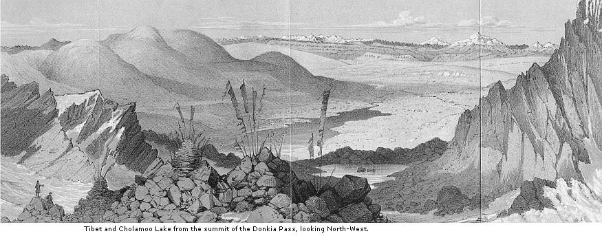
I passed several shallow lakes at 17,500 feet; their banks were green and marshy, and supported thirty or forty kinds of plants. At the head of the valley a steep rocky crest, 500 feet high, rises between two precipitous snowy peaks, and a very fatiguing ascent (at this elevation) leads to the sharp rocky summit of the Donkia pass, 18,466 feet above the sea by barometer, and 17,866 by boiling-point. The view on this occasion was obscured by clouds and fogs, except towards Tibet, in which direction it was magnificent; but as I afterwards twice ascended this pass, and also crossed it, I shall here bring together all the particulars I noted.
The Tibetan view, from its novelty, extent, and singularity,
* On one occasion I ascended this valley, which is very broad, flat, and full of lakes at different elevations; one, at about 17,000 feet elevation is three-quarters of a mile long, but not deep: no water-plants grew in it, but there were plenty of others round its margin. I collected, in the dry bed of a stream near it, a curious white substance like thick felt, formed of felspathic silt (no doubt the product of glacial streams) and the siliceous cells of infusoriæ. It much resembles the fossil or meteoric paper of Germany, which is also formed of the lowest tribes of fresh-water plants, though considered by Ehrenberg as of animal origin. A vein of granite in the bottom of the valley had completely altered the character of the gneiss, which contained veins of jasper and masses of amorphous garnet. Much olivine is found in the fissures of the gneiss: this feral is very rare in Sikkim, but I have also seen it in the fissures of the White gneissy granite of the surrounding heights.
demands the first notice: the Cholamoo lake lay
1500 feet below me, at the bottom of a rapid and rocky descent; it
was a blue sheet of water, three or four miles from north to south,
and one and a half broad, hemmed in by rounded spurs from
Kinchinjhow on one side, and from Donkia on the other: the Lachen
flowed from its northern extremity, and turning westward, entered a
broad barren valley, bounded on the north by red stony mountains,
called Bhomtso, which I saw from Kongra Lama, and ascended with Dr.
Campbell in the October following: though 18,000 to 19,000 feet
high, these mountains were wholly unsnowed. Beyond this range lay
the broad valley of the Arun, and in the extreme north-west
distance, to the north of Nepal, were some immense snowy mountains,
reduced to mere specks on the horizon. The valley of the Arun was
bounded on the north by very precipitous black rocky mountains,
sprinkled with snow; beyond these again, from north to north-west,
snow-topped range rose over range in the clear purple distance. The
nearer of these was the Kiang-lah, which forms the axis or
water-shed of this meridian; its south drainage being to the Arun
river, and its north to the Yaru-tsampu: it appeared forty to fifty
miles off, and of great mean elevation (20,000 feet) the vast snowy
mountains that rose beyond it were, I was assured, beyond the Yaru,
in the salt lake country.* A spur from Chomiomo cut off the view to
the southward of north-west, and one from Donkia concealed all to
the east of north.
The most remarkable features of this landscape were its
* This salt country was described to me as enormously lofty, perfectly sterile, and fourteen days’ march for loaded men and sheep from Jigatzi: there is no pasture for yaks, whose feet are cut by the rocks. The salt is dug (so they express it) from the margin of lakes; as is the carbonate of soda, “Pleu” of the Tibetans.
enormous elevation, and its colours and contrast to the black, rugged, and snowy Himalaya of Sikkim. All the mountains between Donkia pass and the Arun were comparatively gently sloped, and of a yellow red colour, rising and falling in long undulations like dunes, 2000 to 3000 feet above the mean level of the Arun valley, and perfectly bare of perpetual snow or glaciers. Rocks everywhere broke out on their flanks, and often along their tops, but the general contour of that immense area was very open and undulating, like the great ranges of Central Asia, described by MM. Huc and Gabet. Beyond this again, the mountains were rugged, often rising into peaks which, from the angles I took here, and subsequently at Bhomtso, cannot be below 24,000 feet, and are probably much higher. The most lofty mountains were on the range north of Nepal, not less than 120 miles distant, and which, though heavily snowed, were below the horizon of Donkia pass.
Cholamoo lake lay in a broad, scantily grassed, sandy and stony valley; snow-beds, rocks, and glaciers dipped abruptly towards its head, but on its west bank a lofty brick-red spur sloped upwards from it, conspicuously cut into terraces for several hundred feet above its waters.
Kambajong, the chief Tibetan village near this, after Phari and Giantchi, is situated on the Arun (called in Tibet “Chomachoo”), on the road from Sikkim to Jigatzi* and
* I have adopted the simplest mode of spelling this name that I could find, and omitted the zong or jong, which means fort, and generally terminates it. I think it would not be difficult to enumerate fully a dozen ways of spelling the word, of which Shigatzi, Digarchi, and Djigatzi are the most common. The Tibetans tell me that they cross two passes after leaving Donkia, or Kongra Lama, en route for Jigatzi, on both of which they suffer from headaches and difficulty of breathing; one is over the Kambajong range; the other, much loftier, is over that of Kiang-lah: as they do not compliin of Bhomtso, which is also crossed, and is 18,500 feet, the others may be very lofty indeed. The distance from Donkia pass to Jigatzi is said to be ten days’ journey for loaded yaks. Now, according to Turner’s observations (evidently taken with great care) that capital is in latitude 29° 4′ 20″ north, or only seventy miles north of Donkia; and as the yak travels at the rate of sixteen miles a day, the country must be extraordinarily rugged, or the valleys tortuous. Turner took eight or nine days on his journey from Phari to Teshoo Loombo, a distance of only eighty miles; yet he is quoted as an authority for the fact of Tibet being a plain! he certainly crossed an undulating country, probably 16,000 to 17,000 feet high; a continuation eastwards of the Cholamoo features, and part of the same mountain range that connects Chumulari and Donkia: he had always lofty mountains in eight, and rugged ones on either side, after he had entered the Painomchoo valley. It is a remarkable and significant fact that Turner never appears to have seen Chumulari after having passed it, nor Donkia, Kinchinjhow, or Kinchinjunga at any time.
Teshoo Loombo. I did not see it, but a long, stony mountain range above the town is very conspicuous, its sides presenting an interrupted line of cliffs, resembling the port-holes of a ship: some fresh-fallen snow lay at the base, but none at the top, which was probably 18,500 feet high. The banks of the Arun are thence inhabited at intervals all the way to Tingré, where it enters Nepal.
Donkia rises to the eastward of the pass, but its top is not visible. I ascended (over loose rocks) to between 19,000 and 20,000 feet, and reached vast masses of blue ribboned ice, capping the ridges, but obtained no further prospect. To the west, the beetling east summit of Kinchinjhow rises at two miles distance, 3000 to 4000 feet above the pass. A little south of it, and north of Chango Khang, the view extends through a gap in the Sebolah range, across the valley of the Lachen, to Kinchinjunga, distant forty-two miles. The monarch of mountains looked quite small and low from this point, and it was difficult to believe it was 10,000 feet more lofty than my position. I repeatedly looked from it to the high Tibetan mountains in the extreme north-west distance, and was more than ever struck with the apparently immense distance, and consequent altitude of the latter: I put, however, no reliance on such estimates.
To the south the eye wandered down the valley of the
Lachoong to the mountains of the Chola range, which appear so lofty from Dorjiling, but from here are sunk far below the horizon: on comparing these with the northern landscape, the wonderful difference between their respective snow-levels, amounting to fully 5000 feet, was very apparent. South-east the stupendous snowy amphitheatre formed by the flank of Donkia was a magnificent spectacle.
This wonderful view forcibly impressed me with the fact, that all eye-estimates in mountainous countries are utterly fallacious, if not corrected by study and experience. I had been led to believe that from Donkia pass the whole country of Tibet sloped away in descending steppes to the Tsampu, and was more or less of a plain; and could I have trusted my eyes only, I should have confirmed this assertion so far as the slope was concerned. When, however, the levelled theodolite was directed to the distance, the reverse was found to be the case. Unsnowed and apparently low mountains touched the horizon line of the telescope; which proves that, if only 37 miles off, they must, from the dip of the horizon, be at least 1000 feet higher than the observer’s position. The same infallible guide cuts off mountain-tops and deeply snowed ridges, which to the unaided eye appear far lower than the point from which they are viewed; but which, from the quantity of snow on them, must be many thousand feet higher, and, from the angle they subtend in the instrument, must be at an immense distance. The want of refraction to lift the horizon, the astonishing precision of the outlines, and the brilliancy of the images of mountains reduced by distance to mere specks, are all circumstances tending to depress them to appearance. The absence of trees, houses, and familiar objects to assist the eye in the appreciation of distance, throws back the whole landscape; which, seen through the rarified atmosphere of 18,500 feet,
looks as if diminished by being surveyed through the wrong end of a telescope.
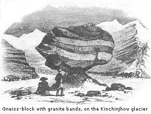
A few rude cairns were erected on the crest of the pass, covered with wands, red banners, and votive offerings of rags. I found a fine slab of slate, inscribed with the Tibetan characters, “Om Mani Padmi hom,” which Meepo allowed me to take away, as the reward of my exertions. The ridge is wholly formed of angular blocks of white gneissy granite, split by frost.* There was no snow on the pass itself, but deep drifts and glaciers descended in hollows on the north side, to 17,000 feet. The rounded northern red shoulder of Kinchinjhow by Cholamoo lake, apparently 19,000 feet high, was quite bare, and, as I have said, I ascended Donkia to upwards of 19,000 feet before I found the rocks crusted with ice,† and the ground wholly frozen. I assume, therefore, that 19,000 feet at this spot is not below the mean level at which all the snow melts that falls on a fair exposure to the south: this probably coincides with a mean temperature of 20°. Forty miles further north (in Tibet) the same line is probably at 20,000 feet; for there much less snow falls, and much more melts in proportion.‡ From the elevation of about 19,300 feet,
* It was not a proper granite, but a highly
metamorphic felspathic gneiss, with very little mica; being, I
suspect, a gneiss which by metamorphic action was almost remolten
into granite: the lamination was obscure, and marked by faint
undulating lines of mica; it cleaves at all angles, but most
generally along fissures with highly polished undulated black
surfaces. The strike of the same rock near at hand was north-west,
and dip north-east, at various angles.
† Snow, transformed into ice throughout its whole mass: in
short, glacial ice in all physical characters.
‡ Two secondary considerations materially affecting the
melting of snow, and hence exerting a material influence on the
elevation of the snow-line, appear to me never to have been
sufficiently dwelt upon. Both, however, bear directly upon the
great elevation of the snow-line in Tibet. From the imperfect
transmission of the heating rays of the sun through films of water,
which transmit perfectly the luminous rays, it follows that the
direct effects of the rays, in clear sunshine, are very different
at equal elevations of the moist outer and dry inner Himalaya.
Secondly, naked rock and soil absorb much more heat than surfaces
covered with vegetation, and this heat again radiated is infinitely
more rapidly absorbed by snow (or other white surfaces) than the
direct heat of the sun’s rays is. Hence, at equal elevations
the ground heats sooner, and the snow is more exposed to the heat
thus radiated in arid Tibet, than in the wooded and grassed
mountains of Sikkim.
which I attained on Donkia, I saw a fine illustration of that atmospheric phenomenon called the “spectre of the Brocken,” my own shadow being projected on a mass of thin mist that rose above the tremendous precipices over which I hung. My head was surrounded with a brilliant circular glory or rainbow.*
The temperature of the Donkia pass is much higher than might be anticipated from its great elevation, and from the fact of its being always bitterly cold to the feelings. This is no doubt due to the warmth of the ascending currents, and to the heat evolved during the condensation of their vapours. I took the following observations:—
| Temp. | D.P. | Differ- ence |
Tension | Humidity | ||
| Sept. 9 Sept. 27 Oct. 19 |
1.30–3.30 p.m. 1.15–3.15 p.m. 3.00–3.30 p.m. |
41·8° 49·2° 40·1° |
30·3° 32·6° 25·0° |
11·5° 16·6° 15·1° |
0·1876 0·2037 0·1551 |
0·665 0·560 0·585 |
* Probably caused by spiculæ of ice floating in the atmosphere, the lateral surfaces of which would then have an uniform inclination of 60°: this, according to the observations of Mariotte, Venturi, and Fraunhœfer being the angle necessary for the formation of halos.
A violent southerly wind, with a scud of mist, and sometimes snow, always blew over the pass: but we found shelter on the north face, where I twice kindled a fire, and boiled my thermometers.* On one occasion I felt the pulses of my party several times during two hours’ repose (without eating); the mean of eight persons was 105°, the extremes being 92° and 120°, and my own 108°.
One flowering plant ascends to the summit; the alsinaceous one mentioned at p. 89. The Fescue grass, a little fern (Woodsia), and a Saussurea† ascend very near the summit, and several lichens grow on the top, as Cladonia vermicularis, the yellow Lecidea geographica, and the orange L. miniata;‡ also some barren mosses. At 18,300 feet, I found on one stone only a fine Scotch lichen, a species of Gyrophora, the “tripe de roche” of Arctic voyagers, and the food of the Canadian hunters; it is also abundant on the Scotch alps.
Before leaving, I took one more long look at the boundless prospect; and, now that its important details were secured, I had leisure to reflect on the impression it produced. There is no loftier country on the globe than that embraced by this view, and no more howling wilderness; well might the Singtam Soubah and every Tibetan describe it as the loftiest, coldest, windiest, and most barren country in the world. Were it buried in everlasting snows, or
* On the 9th of September the boiling-point was
181·3°, and on the 27th, 181·2°. In both
observations, I believe the kettle communicated a higher
temperature to the thermometer than that of the water, for the
elevations deduced are far too low.
† A pink-flowered woolly Saussurea, and Delphinium
glaciale, are two of the most lofty plants; both being commonly
found from 17,500 to 18,000 feet.
‡ This is one of the most Arctic, Antarctic, and universally
diffused plants. The other lichens were Lecidea atro-alba,
oreina, elegans, and chlorophana, all alpine European
and Arctic species. At 17,000 feet occur Lecanora ventosa,
physodes, candelaria, sordida, atra, and the beautiful Swiss
L. chrysoleuca, also European species.
burnt by a tropical sun, it might still be as utterly sterile; but with such sterility I had long been familiar. Here the colourings are those of the fiery desert or volcanic island, while the climate is that of the poles. Never, in the course of all my wanderings, had my eye rested on a scene so dreary and inhospitable. The “cities of the plain” lie sunk in no more death-like sea than Cholamoo lake, nor are the tombs of Petra hewn in more desolate cliffs than those which flank the valley of the Tibetan Arun.
On our return my pony strained his shoulder amongst the rocks; as a remedy, the Lachoong Phipun plunged a lancet into the muscle, and giving me his own animal, rode mine down.* It drizzled and sleeted all the way, and was dark before we arrived at the tent.
At night the Tibetan dogs are let loose, when they howl dismally: on one occasion they robbed me of all my meat, a fine piece of yak’s flesh. The yaks are also troublesome, and bad sleepers; they used to try to effect an entrance into my tent, pushing their muzzles under the flaps at the bottom, and awakening me with a snort and moist hot blast. Before the second night I built a turf wall round the tent; and in future slept with a heavy tripod by my side, to poke at intruders.
Birds flock to the grass about Momay; larks, finches, warblers, abundance of sparrows, feeding on the yak-
* These animals, called Tanghan, are wonderfully strong and enduring; they are never shod, and the hoof often cracks, and they become pigeon-toed: they are frequently blind of one eye, when they are called “zemik” (blind ones), but this is thought no great defect. They average 5 pounds to 10 pounds for a good animal in Tibet; and the best fetch 40 pounds to 50 pounds in the plains of India, where they become acclimated and thrive well. Giantchi (Jhansi-jeung of Turner) is the best mart for them in this part of Tibet, where some breeds fetch very high prices. The Tibetans give the foals of value messes of pig’s blood and raw liver, which they devour greedily, and it is said to strengthen them wonderfully; the custom is, I believe, general in central Asia. Humboldt (Pens. Nar. iv. p. 320) describes the horses of Caraccas as occasionally eating salt meat.
droppings, and occasionally the hoopoe; waders, cormorants, and wild ducks were sometimes seen in the streams, but most of them were migrating south. The yaks are driven out to pasture at sunrise, and home at sunset, till the middle of the month, when they return to Yeumtong. All their droppings are removed from near the tents, and piled in heaps; as these animals, unlike their masters, will not sleep amid such dirt. These heaps swarm with the maggots of two large flies, a yellow and black, affording abundant food to red-legged crows, ravens, and swallows. Butterflies are rare; the few are mostly Colias, Hipparchia, Polyommatus, and Melitæa; these I have seen feeding at 17,000 feet; when found higher, they have generally been carried up by currents. Of beetles, an Aphodeus, in yak-droppings, and an Elaphrus, a predaceous genus inhabiting swamps, are almost the only ones I saw. The wild quadrupeds are huge sheep, in flocks of fifty, the Ovis Ammon called “Gnow.” I never shot one, not having time to pursue them for they were very seldom seen, and always at great elevations. The larger marmot is common, and I found the horns of the “Tchiru” antelope. Neither the wild horse, fox, hare, nor tailless rat, cross the Donkia pass. White clover, shepherd’s purse, dock, plantain, and chickweed, are imported here by yaks; but the common Prunella of Europe is wild, and so is a groundsel like Senecio Jacobæa, Ranunculus, Sibbaldia, and 200 other plants. The grasses are numerous; they belong chiefly to Poa, Festuca, Stipa, and other European genera.
I repeatedly attempted to ascend both Kinchinjhow and Donkia from Momay, and generally reached from 18,000 to 19,000 feet, but never much higher.* The observations
* An elevation of 20,000 and perhaps 22,000 feet might, I should think, easily be attained by practice, in Tibet, north of Sikkim.
taken on these excursions are sufficiently illustrated by those of Donkia pass: they served chiefly to perfect my map, measure the surrounding peaks, and determine the elevation reached by plants; all of which were slow operations, the weather of this month being so bad that I rarely returned dry to my tent; fog and drizzle, if not sleet and snow, coming on during every day, without exception.
I made frequent excursions to the great glacier of Kinchinjhow. Its valley is about four miles long, broad and flat: Chango-khang* rears its blue and white cliffs 4,500 feet above its west flank, and throws down avalanches of stones and snow into the valley. Hot springs† burst from the ground near some granite rocks on its floor, about 16,000 feet above the sea, and only a mile below the glacier, and the water collects in pools: its temperature is 110°, and in places 116°, or 4° hotter than that of the Yeumtong hot-springs, though 4000 feet higher, and of precisely the same character. A Barbarea and some other plants make the neighbourhood of the hot-springs a little oasis, and the large marmot is common, uttering its sharp, chirping squeak.
The terminal moraine is about 500 feet high, quite
* The elevation of this mountain is about 20,560
feet, by the mean of several observations taken from surrounding
localities.
† Supposing the mean temperature of the air at the elevation
of the Momay springs to be 26° or 28°, which may be
approximately assumed, and that, as some suppose, the heat of
thermal springs is due to the internal temperature of the globe;
then according to the law of increment of heat in descending (of
1° for fifty feet) we should find the temperature of 110°
at a depth of 4,100 feet, or at 11,900 feet above the level of the
sea. Direct experiment with internal heat has not, however, been
carried beyond 2000 feet below the surface, and as the ratio of
increment diminishes with the depth, that above assigned to the
temperature of 110° is no doubt much too little. The Momay
springs more probably owe their temperature to chemical
decomposition of sulphurets of metals. I found pyrites in Tibet on
the north flank of the mountain Kinchinjhow, in limestones
associated with shales.
barren, and thrown obliquely across the valley, from north-east to south-west, completely hiding the glacier. From its top successive smaller parallel ridges (indicating the periodic retirements of the glacier) lead down to the ice, which must have sunk several hundred feet. This glacier descends from Kinchinjhow, the huge cliff of whose eastern extremity dips into it. The surface, less than half a mile wide, is exceedingly undulated, and covered with large pools of water, ninety feet deep, and beds of snow, and is deeply corroded; gigantic blocks are perched on pinnacles of ice on its surface, and the gravel cones* are often twenty feet high. The crevassing so conspicuous on the Swiss glaciers is not so regular on this, and the surface appears more like a troubled ocean; due, no doubt, to the copious rain and snow-falls throughout the summer, and the corroding power of wet fogs. The substance of the ice is ribboned, dirt-bands are seen from above to form long loops on some parts, and the lateral moraines, like the terminal, are high above the surface. These notes, made previous to reading Professor Forbes’s travels in the Alps, sufficiently show that perpetual snow, whether as ice or glacier, obeys the same laws in India as in Europe; and I have no remarks to offer on the structure of glaciers, that are not well illustrated and explained in the abovementioned admirable work.
Its average slope for a mile above the terminal moraines was less than 5°, and the height of its surface above the sea 16,500 feet by boiling-point; the thickness of its ice probably 400 feet. Between the moraine and the west flank of the valley is a large lake, with terraced banks, whose bottom (covered with fine felspathic silt) is several
* For a description of this curious phenomenon, which has been illustrated by Agassiz, see “Forbes’s Alps,” p. 26 and 347.
hundred feet above that of the valley; it is half a mile long, and a quarter broad, and fed partly by glaciers of the second order on Chango-khang and Sebolah, and partly by filtration through the lateral moraine.